Yellowstone National Park a été temporairement fermé à la circulation,depuis le 16 juillet 2015, en raison de l’activité thermique qui affecte les routes avoisinantes.
Photo du 19 juillet 2015
Le reponsable de la sécurité du parc a dit qu’une nouvelle activité thermique est devenu visiblement active depuis mai 2015 , près du stationnement de la terrasse supérieure , en voyant des températures allant jusqu’à 152 degrés Fahrenheit.
Voir les rapports:
Les Rangers ont remarqué l’activité thermique supplémentaire cette semaine à côté et sous la chaussée, ce qui a déclenché la fermeture temporaire.
L’imagerie thermique montre la chaleur sous la chaussée .
Employé à Yellowstone,le géologue Dr. Hank Heasler dit, « Nous connaissons bien cette région qui avait la chaleur près de la surface sur la base du fait qu’elle ne retient pas la neige en hiver. Nous avons foré deux trous d’un demi-mètre (20 pouces) de profondeur.Actuellement,il n’y a pas d’eau bouillonnant à la surface ou près de la surface.
Texte d’origine:
(Park geologist Dr. Hank Heasler said, “We have known this area had heat near the surface based on the fact that it does not hold snow in the winter. We drilled two holes a half-meter (20 inches) deep, both of which now have hot water bubbling at the surface or very near the surface.”)
Rangers at Yellowstone National Park have temporarily closed Upper Terrace Drive near Mammoth Hot Springs to vehicles due to a new thermal feature that is affecting the road. (Yellowstone National Park photo)
Les visiteurs du parc sont encore capables de marcher sur la terrasse supérieure .
Le personnel d’entretien se prépare pour protéger les voies de circulation de l’activité thermique .
Une fois la sécurité du parc rétablie,la circulation sera réouverte.
Heasler a noté: »Comme dans toutes les zones thermiques, les visiteurs doivent rester sur les trottoirs ou les zones pavées et éviter de toucher aux caractéristiques thermiques. »
At this point,thebasement ofYellowstone National Parkstandsat a record pace. In fact,it amounts toa rate of aboutthreeinchesper year.The reasonitisso concernedthatthe park isinthesuper-volcano Yellowstone-the largestNorth Americanvolcano.Scientists tell usthat it is inevitablethatfromeruptingagainsomeday, andwhen that happensthe devastationisalmost unimaginable.A completeeruption ofYellowstonesenda thick layer ofvolcanic ashup to 1000miles away,andit would makemuch of theUnited Statesuninhabitable.When mostAmericans think ofYellowstone,they tend toconjure up images ofYogi Bearand « Old Faithful », but the truthis thatsleepingunderYellowstonevolcanicbeastthat could destroyournationin one day, and nowthe beastbegins to awaken.
Cette photo de la fin de 2012,nous montre le dégré élevé de la température sur le site./ This photo of the end of 2012, shows the high degree of temperature on the site. / Esta foto de la final de 2012, muestra el alto grado de temperatura en el sitio. /
At this point,thebasement ofYellowstone National Parkstandsat a record pace. In fact,it amounts toa rate of aboutthreeinchesper year.The reasonitisso concernedthatthe park isinthesuper-volcano Yellowstone-the largestNorth Americanvolcano.Scientists tell usthat it is inevitablethatfromeruptingagainsomeday, andwhen that happensthe devastationisalmost unimaginable.A completeeruption ofYellowstonesenda thick layer ofvolcanic ashup to 1000miles away,andit would makemuch of theUnited Statesuninhabitable.When mostAmericans think ofYellowstone,they tend toconjure up images ofYogi Bearand « Old Faithful », but the truthis thatsleepingunderYellowstonevolcanicbeastthat could destroyournationin one day, and nowthe beastbegins to awaken.
TheYellowstone volcanoisso vast that itis difficult tosummarize in a fewwords.According to the DailyMail,the pocket ofmagma beneathYellowstoneis about 300miles wide…
TheYellowstone calderais oneof the most impressivecreations of natureandsits atopthe largest volcanicfieldin NorthAmerica.
Its name means « pot » and « kettle » and was formedwhen the landcollapsedfollowing a volcanicexplosion.
InYellowstone, some 400 milesbelow the surface ofthe Earthisa « hot spot » of magmathat risesto30 milesundergroundbefore spreadingover an area of300 milesthroughthegeological layers.
At the top,but always underthe surface, is the dormantvolcano.
Délimitation géographique de la caldéra./ Geographic limit of the caldera./ Delimitacion geografica de la cadera.
When mostAmericans think ofvolcanic eruptionsUnited States, they rememberthe catastrophic eruption ofMount St.Helenseruptionin 1980. Butthiswould not even beworth comparingtoafull-blowneruptionof theYellowstonesupervolcano.
And now,the area aroundYellowstoneismoreseismicallyactive. In fact, Dr. Bob Smithsaid hehas neverseen anything like thisin the 53years hewatchedYellowstone…
Until recently,Bob Smithhad neverwitnessed twosuccessionsofsimultaneousearthquakesinits 53yearsofmonitoring seismicactivityin and aroundtheYellowstone caldera.
NowSmith, a professor of geophysicsat the University ofUtah,saw threeestates ofbothearthquakes.
La poussée du grand lac de lave sous la caldeira annonce fort probablement la mort de notre civilisation./ The thrust of the largest lava lake in the caldera announcement likely death of our civilization./ El empuje del mayor lago de lava en el anuncio caldera muerte probable de nuestra civilización.
« Atotal of 130earthquakes of magnitude0.6 to 3.6have occurred inthese three areas,however, mostwerein the lowerGeyser Basin, » said a researcher fromthe Universityof Utah.« In particular, much ofthe seismicityinYellowstoneis asswarms.«
Les limites extrèmes de la grande caldeira./ The extreme limits of the great caldera.
So what’sthe worstscenario?
Well,according to the DailyMail,afulleruptionofYellowstonecould leavetwo-thirdsof the United Statescompletelyuninhabitable…
If we haditexploded,it would withaforcemorepowerful thanthe Mount StHelensin 1980thousand times.
Whilespewingits lavafar into thesky, a cloud of toxic ashassassinateall the vegetationon the ground,ina movementrangeand everything would becovered by agood10 feetinhotacidandlayer depthofup to 1,000miles from there.
Two thirds of theUS couldbecomeuninhabitableastoxic airsweepthrough itall, on land and thousands of flightswerecanceledand millions ofpeople would beforced toleave their homes.
Can youthink of anotherpotentialdisaster that coulddo the same thing?
That is whywhat is happeningin Yellowstoneright now isso important,and the American peopledeserve to know thetruth.Here are somemore explicitfacts aboutYellowstonethatI compiledthatI includedin a previousarticle …
#1Alarge-scaleeruptionofYellowstonecould beup to 1,000 timesmore powerful thanthe eruption of MountSt.Helensin 1980.
#2Alarge-scaleeruptionofYellowstonecouldspitvolcanic ashup to 25milesinto the air.
#3The nexteruption ofYellowstoneseems to be gettingcloserwitheachpassing year.Since 2004, some areas of Yellowstone National Parkincreased bynotless than 10 inchesin height.
#4There are about3,000earthquakes inthe Yellowstone regioneachyearonly.
5 Inthe case of alarge-scaleeruptionofYellowstone,almost allnorthwestof the United Stateswill be completelydestroyed.
#6A massiveeruption ofYellowstonewould mean thatalmost everything ina100 mile radiusofYellowstonewould be killedimmediately.
#7Alarge-scaleeruptionofYellowstonecouldpotentiallydumpa layer ofvolcanicashthat is atleast 10feet in heightup to 1000miles away.
#8Alarge-scaleeruptionofYellowstonecould coveralmost allof theMidwestern UnitedStateswithvolcanic ash.Food productionin America would bealmost completelydestroyed.
#9A « volcanic winter » would be caused by amassive eruptionofYellowstone, which could drasticallycool the planet. Some scientistsbelieve thatglobal temperatures coulddrop to20 degreeson a global scale.
#10Americawould never bethe sameafter a massiveeruption ofYellowstone.Some scientistsbelieve that amajor eruptionofYellowstonewould maketwo-thirdsof the United Statescompletelyuninhabitable.
#11Scientists tell usthatthis is nota question of« if »Yellowstonewillerupt, butrather« when »the nextinevitableeruptionwill take place.
La surface recouverte par plusieurs mètres de cèdres lors des éruptions passées./ The area covered by several meters of ash eruptions during the past surface. / El área cubierta por varios metros de erupciones de ceniza durante la superficie pasado.
What makesall thiseven more alarmingis that anumber of otherprominentvolcanoesin theworld areto goright now as well.
For example,an articleofinquisiterin July 2013describes howstarting to becomevery active…and threatening« the mostdangerousvolcanoin Mexico! »
« ThePopocatepetlvolcano iseruptingagain. The activevolcanonear Mexico Cityhavebroken outagainthis morning, spewing ashinto the sky.«
The volcano iscurrently in the midstof an extremelyactive phase.According to theInternational Business Times, the volcano has registered39exhalationsin the past24 hours.
An eruptionearlierthis monthcaused severalcancellationsofflights in and outofMexico City.
TheBBCnotes thatofficialshave raisedthealertyellowalert levelafter the eruption ofPopocateptlSaturday morning.Yellow isthe level ofcaution tothird intheseven-stepscaleof the city.
AndanNBC NewsarticlefromAugust 2013noted thatoneof the most dangerousvolcanoesin Japancameerupting500 timesso farthis yearin2013!
Ashfloatedas high as3 milesabove thevolcanoSakurajimain the southern cityofKagoshima,on Sundayafternoon, forming its highestsince theplumeJapan Meteorological Agencybegan keepingrecordsin 2006.Dishsankjust overhalf amileof the crack,andseveral hugevolcanic rockstumbled downthe mountain.
Althoughthe eruption wasmore massive thanusual,the inhabitants of thecity of about600,000 inhabitantsareaccustomed to hearingthe mood swingsoftheir neighborof 3,664feet.Kagoshimaofficialssaid ina statement that theeruption wasthe500thofSakurajimainthis year alone.
So whatdoes all thismean?
We are nowentering aperiodwherevolcanic eruptionsbecome muchmore common inthe world?
Could webefast?…Approaching theday whenabsolutelydevastatingvolcanic eruptionwill cripplea large partof NorthAmerica?
Ihope not,becauseit could easilyspell the endof the human race…astrongpart, at least.
The ground begins to overheat in the large caldera. The worst is feared.
Plus on s’approche,plus le constat de danger est grave./ The closer you get, the more serious finding of danger. /
Melting the asphalt is very visible in this picture.
CHEYENNE, Wyoming (AP) –ThegeologyheatevolvingfromYellowstone National Parkhas createda hot spotthat meltsa paved roadand gatedaccess to popularattractionsandthe heightof the tourist seasongeysers,indicatedofficialsThursday, July 10, 2014.
Asthey examinedall possiblesolutions, park officialshave warnedvisitorsnot togo hikingin the affected area, where the dangerof walkingthrough the solidground,like watchingboiling waterwashigh.
For several days, everything was starting to go slow. /
« There are many other placesto seeexcellentthermalfeatures inthe park, » said spokesmanAlNashYellowstone. « I do notwant to riskinjuryduringthis temporary closure. »
The closer you get, the more serious finding of danger. /
« Naturally, » say officials,changes in currentthermal characteristicswill oftendamage roadsand sidewalksYellowstone.Thesteamingpotholesinasphalt roadsand parking–defined bytraffic cones –arefairly commonsights.
There is Firehole Lake in 2005.
…and now ,there is his actual aspect.
However, damage to FireholeLake Driveare particularly seriousand maytake several days tofix everything.3.3mileloopsixmilesnorth ofOld Faithful, is the roadthattakesvisitorsto see theGreat FountainGeyser,White DomeGeyserandFireholelake.
The weather isunseasonably warmforYellowstone –with highin themid-80stemperatures–has helped transformthe road ina warm,sticky mess.
« We have someideas.We’lltry.Our maintenancestaff reallylooked at the issue, » said Nash…which clearlyseeks to reassureus.
OTHERSONSOFBELL
The roadwas badly damagedby theextreme heatinYellowstone National Park, forcing park officialsto closeaccess. TheFireholeLake Drivearealooks like this:a fusion ofheat.
Park officialssaid in apress release thatthe extreme heatof the surroundingtemperature zonescausedasa thick oilbubblesrising to the surface, damaging the bitumenand creatingdangerous driving conditionson the popularandpicturesqueroad neartheGrandLooproadhalfwaybetween OldFaithful andMadisonJunctioninlower Geyser Basinpark.
3.3mileloopusually takesvisitors toGreat FountainGeyser(GreatFaithfull), White DomeGeyserandFireholeLake.
A date forthe reopening of theroad has notbeen announced.
The reporthelpedthe renewedrumors thattheYellowstone caldera, known as VolcanoYellowstonesupervolcanoor, soonburstignition.
TomLupshu, awell-knownbloggerconspiracythat runs theBunkerreportjust posteda new videoclaimingthat the volcanocould explodesoon.Thisreport and thereporton the roadKTVQpress releasehas beenhighlighted bythe site of theconspiracybefore it’snews. « Update! MeltsroadtoYellowstone National Park, causing the closure » He said inhis usualsensationaliststyle.
However, thevideoalso focuses onLupshuscientistssay they have discovered. calderais 2.5 timeslarger thanpreviously thoughtnewsbrokein December 2013Watch the video onthislink. video
Renewedspeculationfollowingacyclethat explodedin March,after a videowas postedshowinganimalsfledtothe park asa « warning » that the volcanowas about toerupt.
The last majoreruptionis thought to haveoccurredabout640,000 yearsagoand sentashacrossNorth America.
BobSmithofthe University ofUtahsaid researchersdo not know whenthesupervolcanocoulderupt again. Two furthereruptions occurred, there is a 2.1 million years, andthere are 1.3millionmore years, Smith said.One theory is thattheeruptions occurthereevery700,000 years, butSmithsaid thatmore dataare needed to safeguardthis theory…untilfurther notice!
AUTHORITIESARE MADEREASSURING
The death zone …around Yellowstone.
Une éruption du volcan de Yellowstone serait possible en 2014 ,selon certains chercheurs à la façon dont les animaux ont été repérés fuyant le parc national ces derniers mois.
Dans un rapport connexe par Le Inquisitor , il est affirmé que les récents tremblements de terre de Yellowstone ne déclencheront pas une éruption volcanique , mais les scientifiques ont reconnu que si un volcan de Yellowstone devait éclater le supervolcan résultant pourrait tuer tout le monde aux États-Unis:
« L’éruption du volcan de Yellowstone pourrait libérer suffisamment de magma et de cendres pour enterrer des villes entières sous des kilomètres de cendres. Les bonnes nouvelles sont que le supervolcan à Yellowstone n’est pas en danger d’explosion de sitôt. La dernière fois que cela s’est produit,c’ était avant l’aube de la civilisation. S’ils croient qu’arrêter une éruption est impossible, les scientifiques disent qu’ils devraient être en mesure de prédire une éruption en surveillant la pression du magma souterrain « .
Les tremblements de terre récents qui viennent de faire les nouvelles, mais l’ensemble de la zone gronde depuis le début de l’année 2014. Les graphiques de l’USGS montrent que les tremblements de terre supérieurs à 3.0 ampleur se sont produits loin et dessus pendant plusieurs jours et tous sont venus de la région de la chambre magmatique de Yellowstone, qui, selon un radar à pénétration de sol, s’étend à l’ouest jusqu’au la ligne d’état de l’Orégon.
Malheureusement, disent les défenseurs de la science officielle :certains théoriciens de la conspiration revendiquent que l’USGS essait de cacher la possibilité d’une éruption du volcan de Yellowstone se produisant actuellement,dans notre vie. Pour preuve qu’ils utilisent des vidéos comme celles-ci qui montrent prétendument …des buffles « courir pour sauver leur vie » loin du parc national de Yellowstone:
Map of the study of Russian scientists: a large magnetic anomaly on the American West Coast (orange yellow).
A grimreport prepared by theCommander in Chief ofthe Russian AirForce, Lieutenant-GeneralViktorBondarevon scientificmission whichhadjust completedoverNorthAmericamission carried outbyfourTupolev Tu-95, strategic airliftand 2IlyushinIl-78 tankersthat « by electronic scanning » for « magnetic anomalies »from Alaska toCalifornia, warns that a« catastrophic event » can be almostfor this region.
U.S. officials, it should be noted, described the missionas apurelyscientific« bombing run » that camewithin 50 milesof California,buttheir air forceswere able topushwith the launchof theF-15 combat.
However, the reportindicates that thescientific missionwas necessitatedbya « seriousmysteriousmagnetic anomaly » detected by thesatelliteKosmos2473June 3, 2014, occurring in the Yellowstone region, west of the United Stateswhich ledwhat is calleda« swarm of earthquakes. «
Themost important thing tonote about the3 June 2014, Yellowstoneis this« magnetic anomaly », the report continuesthatsatellite measurementsshow that it isprecipitated by theswarm ofearthquakesthatmysterioushit theBrooksmountainRange, Alaska, andseismologistsare stilllooking forexplanations.
Information onthe binding of thesetwo « events » in this reporthave also beenverified bytheUnited States GeologicalSurvey (USGS) maps and data onthe magnetic anomaliesfor NorthAmerica showinga fieldmagnetic« perturbation/undulation » strangefromBrooksRangeand ending onJune 3Yellowstone.Lethese twoareas, it isimportant to note thatBrooksRangeis partof the Rocky Mountainsthat extendmore than4830 km(3000miles)in the northern partof BritishColumbia,in westernCanada, to New Mexicoin thesouthwesternUnited States.
« These are serious concernsforthe Russian military authoritieson these » events « , says GeneralBondarev‘s report, it was the » catastrophic effect « they had on advancedsystems »magnetoception« of inertialnavigationused by manyUS-NATO-Russian war planesthat use thesesophisticateddevicesinflight.
An important magnetic perturbation is on the road.
Although noRussian military aircraftwasnear the « magnetic disturbed area » fromourYellowstone,June 3, 2014, in this report,twoU.S. military aircraftwerewithintheir« frontier »in the southern regionCalifornia, June 4, while this« event »was still« active », making plantfloor,both.
The twoAmerican fighter planescrashedJune 4, 2014, the report said. Aircrafthave been identified asaU.S. NavyFA-183 crashedwhileattempting to landaboard theaircraft carrierCarlVinson,ajetandU.S. MarineAV-8BHarriercrashedin a residential areain Imperial,totheapproximately 90miles east ofSanDiego, the two accidents inthe same hours.
The reportnotes that nocivilian aircrafthave beenhit bythis « magnetic anomaly » that the mostadvancedmilitary aircraftusing thesesystemscoordinatedflight« geomagnetic planet » that allow them to « kiss the ground »is not withoutremembermagnetic systemsused by birdsand insectsto navigate.
ConcernsregardingRussia« magnetic anomalies », it is important to note, are related tothe magnetic north poleismoving rapidlysince 2005whichwas movedat a speed of40 kilometers (25 miles) per yearin the Canadian Arcticto Siberia.
A scaryindependent researchlast year(2013)alsowarnsthat this changeis accelerating, andyetaccording tothis researcheris expected toSiberiaat least2 years.
One effectof themagnetic north poleismovingquicklynoticedmostisthereportnotes: systemsairport runwayaredisturbedbecause of this, and we can readasan exampleof 2011thattook place in theStatesUSA:
« Tampa International Airport was forced toreadjustits runwaysThursday toaccount for themovement ofmagneticfields of the Earth, information thatpilots useto navigateplanes. Fromthefluctuationsof the force, the airport closed itsprimary runwayuntilJan. 13to changetaxiwaysignsto account forevolution,saystheFederal Aviation Administration.
The polesare generated bymovements withinthe inner and outercoreof the Earth,although the exactprocess is notexactlyknown. They are alsoconstantly in motion, moving a few degreesevery year, but the changes are almost neverof such a magnitudethatrunwaysrequireadjusting, said PaulTakemoto, aspokesman fortheFAA. «
The mostdisturbingreport of the Secretary-General Bondarevon these« events »areaspectsequationsit usesto postulate thatthisis happening nowin North Americawiththe« mysteriousmagneticanomalies »occurover a wide rangeofRocky Mountains,and when combinedwiththe rapidly changingmagnetic north poleandmore, it gives evidenceof global climate change, giving a « huge credibility » to what is called« the theory of Earthexpansion. «
The expansionof the Earth ormorethe hypothesis ofEarthexpansion, says the positionandthe relative movement ofcontinentsis at least partiallydue to the volumeof the Earthincreasinglyhighand standsunlike thatofplate tectonics, butnewfindings on« theories of the ether » and dark matter, General Bondarevsummary, this meansthat« seriousconsideration »should be givenundertheDavisUniversityCalifornie.Lecosmologist, Dr. AndreasAlbrechtwarned: « We have achieved somevery deepproblems withcosmology… allwithdark matter anddarkenergy,which tells us thatwe need to rethinkthephysicalbasic andtrysomething new. «
Orin simple terms,thisreport concludes: « We canbe on the vergeof a catastrophicNorth America » event « that could change the world forever, we must be ready. »
…………………………………………………………………………………………………………………………..
PHOTOGRAPHICEVIDENCE
Graph showing the two major seismic epicenters.
The American West Coast (San Andreas Fault) Mississippi (San Madre Fault) and to Yellowstone … a great magnetic anomaly has occurred.
/ Operations fracking search for shale gas might even affect. Even capitalism contributes to the eruption of Yellowstone.
Brooks Range is at left at the top.
View of Firehole Lake from the sky.
Norris Basin,a bowling water.
The earthquakes of March 24, 2014.
When the Yellowstone supervolcano will erupt, it will be the end of many animal species on Earth …
All my thoughts are with these great Bisons Park Yellowstone.Je wants them to live as long as possible.
La carte ci-dessus montre le déplacement, vers le sud ouest, des événements vulcanologiques en fonction du temps. Yellowstone se situe à la verticale d’un « point chaud », c’est à dire de l’extrêmité d’une remontée de magma chaud en provenance des tréfonds de l’écorce terrestre, qui joue le rôle d’un « chalumeau ». Il existe à Yellowstone un lac, circulaire. Fin juillet 2004 les géologues ont découvert que le fond de ce lac était remonté de … 30 mètres. Sur la carte ci-après la zone où cette remontée de fond a été constatée. Quant à la température de l’eau à cet endroit, elle atteint actuellement 88° et ne cesse de croître. Il faut garder en tête que le parc est à une altitude relativement élevée. Ce lac est maintenant fermé au public et sa température se couvre de poissons morts (source : The Idaho Observer). La situation est identique dans la rivière Yellowstone ainsi que dans les différents cours d’eau de la région qui charrient également nombre de poissons passés de vie à trépas. Beaucoup d’aires de pique-nique ont dû être fermées. Dans de nombreuses régions du parc la durée des visites se limite d’elle-même à quelques heures tant la puanteur des remontées sulfureuses est devenue insupportable.Le déplacement du point chaud,en dessous du Parc de Yellowstone.
L‘examen du site du parc Yellowstone a permis de montrer qu’on était là en présence de la caldeira d’un « super-volcan », sous laquelle se cacherait une chambre magmatique gigantesque. L’examen de l’environnement a permis en outre de montrer que la périodicité de ses éruptions était de 600.000 ans. Or la dernière éruption date de 630.000 ans. Par rapport aux chiffres ce super-volcan aurait donc 30.000 ans de retard.
Mais il n’y a pas que cela. En 2003 les rangers ont décidé d’interdire l’accès du bassins des geysers de Norris au public. La raison : une aire correspondant à 50 km sur 12 s’est soulevée d’une douzaine de centimètres depuis 1996. Sur cette sorte de bombement la température s’est accrue de … 200°, ce qui n’est pas rien. Ce bombement traduit le gonflement d’une chambre magmatique située 500 mètres en dessus de la surface. Les géologues estiment que ce relief se serait surélevé de 70 cm depuis un siècle. Ces modifications ont entraîné un dépérissement complet de la flore et de la faune. Les animaux fuient même carrément la région et n’ont pas attendu les mises en garde des rangers.
………………………………………………………………………………….
Afin de vous garder au courrant de ce qui se passe,je publierai un compte-rendu à toutes les 2 semaine minimum.
Comme nous sommes branchés sur plusieurs site et de nombreuses Webcam,voici quelques photos du 12 février 2014:
Mammoth cam 2
Nous observons ici le centre de la caldeira.
Autre point de vue sur le centre de la caldeira.Nous constatons des émanations de fumée.Le sol est beaucoup plus chaud ici.
……………………………………………………………………………………….
ARRET SUR ARTICLE
Évalué à plus de 630 kilomètres de long.
La taille du « super volcan » situé sous le parc national de Yellowstone, dans le Wyoming aux États-Unis, serait bien plus importante que celle estimée jusqu’à présent. Des scientifiques doivent publier une étude dans la revue Geophysical Research Letters pour rendre compte de l’immensité du panache sous-terrain de roches chaudes. Les dernières estimations établies par les scientifiques révèlent que le volcan souterrain du site de Yellowstone s’étendrait sur une distance de près de 643 kilomètres d’est en ouest, selon le National Geographic. Pour en arriver à de tels résultats, les chercheurs ont utilisé la méthode de conductivité électrique, une technique basée sur l’aptitude de chaque matériau à laisser passer le courant électrique.
Ils ont, pour ce faire, utilisé des dizaines de stations de surveillance mesurant l’intensité des ondes électromagnétiques générées dans l’ionosphère, une couche électriquement chargée de la haute atmosphère terrestre. Ces ondes ont la propriété de pénétrer profondément dans la terre en affectant la variation de la conductivité électrique des matériaux qu’ils rencontrent. Les images magnétotelluriques qui résultent de ce protocole sont très semblables à celles obtenues par des techniques d’échographie ou d’IRM dans le domaine de la santé. Grâce à ces résultats, les chercheurs ont pu constater que l’ensemble de roches chaudes du volcan sous-terrain s’étendait bien au delà des premières estimations établies à partir des mesures sismiques de 2009. Un très ancien volcan Après sa dernière grosse activité il y a 640.000 ans, le « supervolcan » de Yellowstone, s’est petit à petit transformé en caldeira, une dépression en forme de cercle qui résulte de l’effondrement de la partie centrale d’un volcan. Une trentaine d’éruptions moins importantes ont depuis rythmé la vie du cratère le remplissant de laves et de cendres jusqu’à le transformer en une vaste plaine. La découverte du volcan enfoui remonte à 2004 suite à la constatation d’une remontée du terrain d’environ 7 centimètres par an. Les scientifiques avaient alors découvert un réservoir de magma situé à environ 10 kilomètres de la surface. Ce réservoir s’approvisionne d’un panache de roches très chaudes provenant du manteau de la Terre. Grâce aux images magnétotelluriques récoltées par les nouvelles recherches, les chercheurs ont réalisé une carte représentant les caractéristiques de la croûte terrestre et du manteau supérieur jusqu’à 320 kilomètres de profondeur. Ces nouvelles représentations devraient leur permettre de construire de meilleurs modèles géologiques de la surface terrestre.
Sur le site de Yellowstone, parc national situé dans le Wyoming aux Etats-Unis, des experts ont observé des déformations du sol. Après plusieurs mesures, ils ont constaté que celui-ci était plus élevé de 25 centimètres à certains endroits qu’en 2004 ! A Yellowstone, le paysage a connu un changement exceptionnel. C’est ce que rapportent, dans la revue National Geographic, plusieurs scientifiques. Le volcan qui s’y trouve aurait pris une « profonde inspiration » et aurait, par conséquent, poussé le sol vers le haut par endroits.Ce volcan, qui bouillonne, a connu des éruptions dans le passé qui furent à chaque fois mille fois plus puissantes que celle du Mont St-Helens en 1980. La caldeira de Yellowstone, qui couvre une surface de 40 x 60 kilomètres dans le Wyoming, est un ancien cratère formé après la dernière grosse activité de ce « supervolcan », il y a 640.000 ans. Depuis, environ 30 « petites » éruptions ont rempli cette caldeira de lave et de cendres, et le paysage était relativement plat. Mais depuis 2004, les scientifiques ont remarqué que le terrain prenait de la hauteur (environ 7 centimètres par an, pour ralentir à 1 centimètre par an ou moins à partir de 2007). Au total, le sol s’est élevé à plus de 25 centimètres comparé au niveau de 2004. Selon les experts cités par National Geographic, il y aurait un réservoir de magma qui gonflerait dans les profondeurs, à environ 10 kilomètres de la surface. Heureusement, cette brusque montée du terrain ne présage pas de catastrophe imminente. Les experts veulent tout de même se pencher sur ce phénomène, qui leur permettra sans doute de savoir quand aura lieu la prochaine éruption. L’observatoire volcanique de Yellowstone du U.S. Geological Survey (USGS) a d’ailleurs commencé à cartographier la caldeira et ses parties « gonflées » en utilisant des systèmes GPS et un radar synthétique interférométrique d’ouverture, qui permet de mesurer les déformations du sol. Un phénomène cyclique La théorie actuelle est la suivante : un réservoir de magma se nourrit d’un panache de roche très chaude en provenance du manteau de la Terre. Lorsque la quantité de magma augmente, le réservoir se gonfle et la surface, qui nous est visible, s’étend. Selon les données géologiques recueillies sur Yellowstone, il y aurait un cycle d’inflation et de déflation depuis les 15.000 dernières années. Le phénomène ne serait donc pas nouveau.National Geographic donne l’exemple de mesures faites entre 1976 et 1984 : la caldeira a pris 18 centimètres de haut, pour ensuite retomber, une dizaine d’années plus tard à 14 centimètres.Le système hydrothermal qui se trouve sous la surface de Yellowstone pourrait aussi jouer un rôle dans ces déformations du sol. Tout comme les 3.000 séismes qui secouent le site chaque année.
…………………………………………………………………………………………
Mammoth3 Cam: oriernté vers les hauteurs.
Seconde caméra orientée vers les hauteurs nord du parc.
Le secteur de Old Faithfull laisse échapper un brouillard de vapeur.
La caméra du mont Washburn semble endormie.
Nous reviendrons faire une mise à jour sur cet article à toutes les 2 semaine!À la prochaine les ami(e)s!
** flash ** indications of severe earthquake / eruption at yellowstone national park
*** FLASH *** INDICATIONS OF SEVERE EARTHQUAKE / ERUPTION AT YELLOWSTONE NATIONAL PARK Sunday, 02 February 2014 05:06
— (TRN) — A seismometer inside a borehole at Yellowstone National Park has begun reporting staggering underground activity near the southwest corner of Yellowstone Lake, possibly signaling the beginning of an eruption of the Super Volcano at the Yellowstone National Park. TRN has obtained the image of the Seismograph report and now YOU can see it for yourself! This could be very nasty. . .
Yellowstone lake is pretty much the center of what is the Yellowstone Caldera; the mouth of a massive Super Volcano, located beneath the park.
The activity began around 12:00 Noon, Mountain Standard Time (MST) on February 1, and was detected by a seismometer in Borehole B944 then continued, non-stop, all day yesterday getting worse and worse as the hours wore on. The activity is continuing right now at 6:06 EST AM as this news article is being produced.
The map below shows the location of Borehole B944 in relation to Yellowstone Lake and the rest of the park.
The readings being reported from seismometer inside Bore Hole #B944 are literally « off-the-scale. » Is an earthquake brewing, or is this the beginning of a catastrophic eruption of the Yellowstone « Super Volcano? »
Seismographic Printout from Yellowstone National Park, Bore Hole #B944, for February 1, 2014. The time stamp goes down the left edge. Look at what starts happening from 12:00 Noon for the rest of the day. By 3:00 PM MST, things get real dicey; by 5:00, it is clear there’s real trouble happening underground. By 7:00 PM, the seismographic gear is totally overwhelmed; with all readings going utterly off the scale. This could be a sign that a massive eruption of the Yellowstone Super Volcano has begun deep underground.
CLICK IMAGE TWICE TO VIEW FULL SIZE
A second printout shows the activity continuing to this very moment, so severely that the seismometer printer is RUNNING OUT OF BLUE, BLACK AND GREEN INK!
Here is the activity from Midnight MST to 4:30 AM, MST (5:30 AM EST)
CLICK IMAGE TWICE TO VIEW FULL SIZE
PERSPECTIVE ON THE ENORMITY OF YELLOWSTONE
To help readers understand the implications of what is taking place, we first show the enormity of Yellowstone National « »PARK » with stats from the US National Park Service:
•Yellowstone was the world’s first National Park •A designated World Heritage Site and designated Biosphere Reserve •3,472 square miles or 8,987 square km •2,221,766 acres or 898,317 hectares •63 air miles north to south (102 km) •54 air miles east to west 87 km) •96 % in Wyoming •3 % in Montana •1 % in Idaho •Highest Point: 11,358 ft / 3,462 m (Eagle Peak) •Lowest Point: 5,282 ft / 1,610 m (Reese Creek) •Larger than Rhode Island and Delaware combined •About one-quarter the size of Switzerland and about 65% the size of Montenegro
•Approximately 5% of park is covered by water; 15% is grassland; and 80% is forest •Precipitation ranges from 10 inches (26 cm) at the north boundary to 80 inches (205 cm) in the southwest corner •Temperatures (average) at Mammoth: January: 9° F/-13 C in July: 80° F/27 C •Records: High: 99°F/37 C, 2002 (Mammoth) Low Temp: -66° F/-54 C (West Entrance, Riverside Station 1933) Here’s a map of Yellowstone:
Here is a Topographical map showing the mouth (« Caldera ») of the Super Volcano and the scarred, treacherous terrain, created by past eruptions. (Click Image to enlarge). The park boundaries are the thin Yellow line, the Caldera of the super volcano is shown by the thin Red line. Bear in mind that seismometer B944 is just next to the area labeled ‘West Thumb » on the map, showing the western edge of Yellowstone Lake. That puts this seismic activity right smack in the active zone of the actual caldera.
A recent program aired by the British Broadcasting Corporation (BBC) *** THEORIZED *** what an eruption of Yellowstone would affect. Below is the *** THEORETICAL *** blast, damage and volcanic ash fallout area, which is shown in various shades of Orange.
(This image does NOT reflect an ongoing eruption — it is not real)
If this is the start of an eruption at Yellowstone, the entire northwest quadrant of the country could be affected by damage and disruption beyond human comprehension.
This photo of the end of 2012, shows the high degree of temperature safe site.
At this time, the basement of the Yellowstone National Park stands at a record pace. In fact, it amounts to a rate of about three centimeters per year. The reason this is so concerned that the park is under the Yellowstone super- volcano – largest North American volcano. Scientists tell us that it is inevitable that between erupt again someday, and when that happens the devastation is almost unimaginable. Complete eruption of Yellowstone send a thick layer of volcanic ash up to 1,000 miles away, and it would make much of the United States uninhabitable. When most Americans think of Yellowstone, they tend to conjure up images of Yogi Bear and » Old Faithful » , but the truth is that sleeping under Yellowstone volcanic beast that could destroy our nation into a single day, and now the beast begins to awaken .
The Yellowstone volcano is so vast that it is difficult to summarize in a few words. According to the Daily Mail, the pocket of magma beneath Yellowstone is about 300 miles wide …
The Yellowstone Caldera is one of the most impressive creations of nature and sits atop the largest volcanic field in North America.
Its name means « pot » and it is formed when the earth collapsed following a volcanic explosion.
In Yellowstone, some 400 miles beneath the surface of the Earth is a « hot spot » of magma that rises to 30 miles underground before spreading over an area of 300 miles through the geological layers.
At the top, but always under the surface, is the dormant volcano that.
Geographical limits of the caldeira.
When most Americans think of volcanic eruptions in the United States, they remember the catastrophic eruption of Mount St. Helens in 1980. But this eruption would not even worth comparing to a full eruption of the Yellowstone supervolcano.
And now, the area around Yellowstone is more seismically active. In fact, Dr. Bob Smith says he has never seen anything like it in the 53 years he watched Yellowstone …
Until recently, Bob Smith had never witnessed two successions of earthquakes simultaneously with its 53 years of monitoring seismic activity in and around the Yellowstone caldera.
Now Smith, a professor of geophysics at the University of Utah, saw three estates of both earthquakes.
The thrust of the large lava lake in the caldera announcement likely death of our civilization.
In September 2013, 130 earthquakes hit Yellowstone during a single week. This has made many observers extremely concerned about Yellowstone …
The last succession earthquakes in Yellowstone began on September 10 and trembled until about 11:30 on September 16
« A total of 130 earthquakes of magnitude 0.6 to 3.6 have occurred in these three areas, however, most have occurred in the lower Geyser Basin, » said a researcher from the University of Utah. « In particular much of the seismicity in Yellowstone is as swarms. «
The extreme limits of the Great caldeira.
So what’s the worst case scenario?
Well, according to the Daily Mail, a full eruption of Yellowstone could leave two-thirds of the United States completely uninhabitable …
If it had exploded, it would with a force more powerful than the Mount St Helens in 1980 thousand times.
While spewing its lava far into the sky, a cloud of toxic ash assassinate all the vegetation on the ground, in a movement range and everything would be covered by a good 10 feet in hot acid and layer depth of up to 1,000 miles there.
Two-thirds of the U.S. could become uninhabitable as toxic air sweep through it all , land and thousands of flights were canceled and millions of people were forced to leave their homes.
Can you think of another potential disaster that could do the same thing ?
That is why what is happening in Yellowstone right now is so important, and the American people deserve to know the truth. Here are some more explicit facts about Yellowstone that I compiled that I included in a previous article …
# 1 A large-scale eruption of Yellowstone could be up to 1000 times more powerful than the eruption of Mount St. Helens in 1980.
# 2 A large-scale eruption of Yellowstone could spewing volcanic ash up to 25 miles in the air.
# 3 The next eruption of Yellowstone seems to be getting closer with each passing year. Since 2004 , some areas of Yellowstone National Park increased by not less than 10 inches in height.
# 4 There are about 3,000 earthquakes in the Yellowstone region each year only.
5 In the case of a large-scale eruption of Yellowstone, almost all north -west of the United States will be completely destroyed.
# 6 A massive eruption of Yellowstone would mean that almost everything in a 100 mile radius of Yellowstone would be killed immediately.
# 7 A large-scale eruption of Yellowstone could potentially pour a layer of volcanic ash that is at least 10 feet in height up to 1000 miles away.
# 8 A full-scale eruption of Yellowstone could cover almost all of the Midwestern United States with volcanic ash. Food production in America is almost completely destroyed.
# 9 A » volcanic winter » would be caused by a massive eruption of Yellowstone , which could drastically cool the planet . Some scientists believe that global temperatures could drop to 20 degrees on a global scale .
# 10 America would never be the same after a massive eruption of Yellowstone. Some scientists believe a major eruption of Yellowstone would make two-thirds of the United States completely uninhabitable .
# 11 Scientists tell us that this is not a question of « if » Yellowstone will erupt , but « when » the next inevitable eruption will occur.
From the eruptions of the pas,this complete surface was recover by many meters of ashes.
What makes all this even more alarming is that a number of other prominent volcanoes in the world are to go right now as well .
For example, an article of inquisiter in July 2013 describes how starting to become very active … and threatening » the most dangerous volcano in Mexico ! »
» The Popocatepetl volcano is erupting again . ‘s Active volcano near Mexico City to burst this morning again, spewing ash into the sky . «
The volcano is currently in the midst of an extremely active phase. According to the International Business Times , the volcano recorded 39 exhalations in the past 24 hours.
An eruption earlier this month has caused several cancellations of flights in and out of Mexico City .
The BBC notes that officials have raised the alert yellow alert level after the eruption of Popocateptl Saturday morning. Yellow is the level of warning for third at seven-step scale of the city.
And an article by NBC News from August 2013 noted that one of the most dangerous volcanoes in Japan came erupting 500 times so far in this year 2013!
Ash floated as high as 3 miles above the volcano Sakurajima in the southern city of Kagoshima on Sunday afternoon , forming its highest since the plume Japan Meteorological Agency began keeping records in 2006. Lava flowed just over half a mile of the crack , and several huge volcanic rocks tumbled down the mountain.
Although the eruption was more massive than usual, the inhabitants of the city of about 600,000 inhabitants are accustomed to hearing the mood swings of their neighbor to 3,664 feet. Kagoshima officials said in a statement that the eruption was the 500th of Sakurajima in this year alone. So what does all this mean?
We are now entering a period where volcanic eruptions become much more common in the world?
Could we be fast? Approaching the day … absolutely devastating volcanic eruption will cripple much of North America?
I hope not, because it could easily spell the end of the human race … a strong part , at least .
Cette photo de la fin de 2012,nous montre le dégré élevé de la température sur le site.
En ce moment, le sous-sol du parc national de Yellowstone s’élève à un rythme record. En fait, il s’élève à un rythme d’environ trois centimètres par an. La raison pour laquelle cela préoccupe autant est que sous le parc se trouve le super-volcan de Yellowstone- le plus grand volcan d’Amérique du Nord. Les scientifiques nous disent qu’il est inévitable qu’il entre de nouveau en éruption un jour, et lorsque cela arrivera la dévastation sera presque inimaginable. Une éruption complète du volcan de Yellowstone enverrait une épaisse couche de cendres volcaniques jusqu’à 1000 miles de là, et cela rendrait en grande partie les Etats-Unis inhabitables. Quand la plupart des Américains pensent à Yellowstone, ils ont tendance à évoquer des images de Yogi l’ours et « Old Faithful », mais la vérité c’est que sous Yellowstone dort une bête volcanique qui pourrait détruire notre nation en une seule journée, et maintenant la bête commence à se réveiller.
Le volcan de Yellowstone est si vaste qu’il est difficile de le résumer en quelques mots. Selon le Daily Mail , la poche de magma sous Yellowstone est d’environ 300 miles de large …
La caldeira de Yellowstone est l’une des créations les plus impressionnantes de la nature et se trouve au sommet le plus grand champ volcanique de l’Amérique du Nord.
Son nom signifie «marmite» ou «chaudron» et il s’est formé lorsque la terre s’effondra suite à une explosion volcanique.
Dans Yellowstone, quelque 400 miles sous la surface de la Terre se situe un «point chaud» de magma qui s’élève à 30 miles souterrains avant de s’étendre sur une superficie de 300 miles à travers les couches géologiques.
Au sommet, mais toujours sous la surface, se trouve le volcan qui sommeille.
Délimitation géographique de la caldéra
Quand la plupart des Américains pensent à des éruptions volcaniques aux États-Unis, ils se souviennent de l’éruption catastrophique du mont St. Helens en 1980. Mais cette éruption ne serait même pas la peine de comparer à une éruption à part entière du Yellowstone supervolcano.
Et maintenant, la zone autour de Yellowstone est de plus en plus sismiquement active. En fait, le professeur Bob Smith dit qu’il n’a jamais rien vu de tel dans les 53 années qu’il a regardé Yellowstone…
Jusqu’à récemment, Bob Smith n’avait jamais été témoin de deux successions de tremblements de terre simultanées dans ses 53 ans de surveillance de l’activité sismique dans et autour de la caldeira de Yellowstone.
Maintenant, Smith, un professeur de l’Université de géophysique Utah, a vu trois successions de séismes à la fois.
La poussée du grand lac de lave sous la caldeira annonce fort probablement la mort de notre civilisation.
En Septembre 2013, 130 tremblements de terre frappent Yellowstone au cours d’une seule semaine. Cela a rendu de nombreux observateurs Yellowstone extrêmement préoccupés …
Les dernières successions de tremblements de terre de Yellowstone ont commencé le 10 septembre et tremblaient jusqu’à environ 11h30 le 16 septembre
« Un total de 130 séismes de magnitude 0,6 à 3,6 ont eu lieu dans ces trois domaines, cependant, la plupart ont eu lieu dans le bassin inférieur du Geyser, » affirme une chercheuse de l’ Université de l’Utah . « Notamment une grande partie de la sismicité dans Yellowstone se passe comme essaims. »
Les limites extrèmes de la grande caldeira.
Alors, quel est le pire scénario?
Eh bien, selon le Daily Mail , une éruption à part entière de Yellowstone pourrait laisser les deux tiers des Etats-Unis complètement inhabitable …
S’il fallait qu’il explose ,il le ferait avec une force d’un millier de fois plus puissante que le Mont St Helens en 1980.
Tout en crachant sa lave loin dans le ciel, un nuage de cendres toxiques assassinerait toute la végétation au sol ,dans un mouvement en éventail et tout serait recouvert d’un bon 10 pieds de couche acide et chaude en profondeur jusqu’à 1.000 miles de là.
Les deux tiers des États-Unis pourraient devenir totalement inhabitables pendant que l’air toxique balaierait tout à travers elle, sur terre et des milliers de vols seraient annulé et des millions de gens seraient forcer à quitter leur foyer.
Pouvez-vous penser à une autre catastrophe potentielle qui pourrait faire la même chose?
C’est pourquoi ce qui se passe à Yellowstone en ce moment est si important, et le peuple américain méritent de connaître la vérité. Voici quelques faits plus explicites sur Yellowstone que j’ai compilé que j’ai inclus dans un précédent article …
# 1 Une éruption à grande échelle de Yellowstone pourrait être jusqu’à 1000 fois plus puissante que l’éruption du mont St. Helens en 1980.
# 2 Une éruption à grande échelle de Yellowstone pourrait cracher des cendres volcaniques jusqu’à 25 miles en l’air .
# 3 La prochaine éruption de Yellowstone semble devenir de plus près avec chaque année qui passe. Depuis 2004, certaines zones du parc national de Yellowstone ont augmenté de pas moins de 10 pouces d’élévation .
5 Dans le cas d’une éruption à grande échelle de Yellowstone, la quasi-totalité au nord-ouest des États-Unis sera complètement détruit.
# 6 Une éruption massive de Yellowstone voudrait dire que presque tout dans un rayon de 100 mile de Yellowstone serait tué immédiatement.
# 7 Une éruption à grande échelle de Yellowstone pourrait aussi potentiellement déverser une couche de cendre volcanique qui est d’au moins 10 pieds de hauteur jusqu’à 1000 miles de là .
# 8 Une éruption à grande échelle de Yellowstone pourrait couvrir la quasi-totalité du Midwest des États-Unis avec de la cendre volcanique. La production alimentaire en Amérique serait presque totalement anéantie.
# 9 Un « hiver volcanique » serait causé par une éruption massive de Yellowstone ,ce qui pourrait radicalement refroidir la planète. Certains scientifiques estiment que les températures mondiales pourraient diminuer jusqu’à 20 degrés à l’échelle globale.
# 10 L’Amérique ne serait plus jamais la même après une éruption massive de Yellowstone. Certains scientifiques estiment qu’une éruption majeure de Yellowstone rendrait les deux tiers des Etats-Unis complètement inhabitable.
# 11 Les scientifiques nous disent que ce n’est pas une question de «si» Yellowstone va entrer en éruption, mais plutôt «quand» la prochaine éruption inévitable aura lieu.
La surface recouverte par plusieurs mètres de cèdres lors des éruptions passées.
Ce qui rend tout cela encore plus alarmant, c’est qu’un certain nombre d’autres volcans très en vue dans le monde sont en train de revenir en en ce moment ainsi.
Par exemple, un article de inquisiter de en Juillet 2013 décrit comment «le volcan le plus dangereux au Mexique» commence à devenir très actif …et menaçant!
« Le volcan Popocatepetl est à nouveau en éruption. Le volcan actif près de Mexico ont à nouveau éclaté ce matin, crachant des cendres dans le ciel. »
Le volcan est actuellement au milieu d’une phase extrêmement active. Selon les International Business Times , le volcan a enregistré 39 exhalaisons au cours des dernières 24 heures.
Les BBC note que les fonctionnaires ont soulevé l’alerte jaune de niveau d’alerte après l’éruption du Popocateptl le samedi matin. Le jaune est le niveau de mise en garde au troisième rang à l’échelle en sept étapes de la ville.
Et un article de Nouvelles NBC à partir de Août 2013 notait que l’un des volcans les plus dangereux au Japon est entré 500 fois en éruption jusqu’ici en cette année 2013 !
La cendre flottait aussi haut que 3 miles au-dessus du volcan Sakurajima dans la ville méridionale de Kagoshima, le dimanche après-midi, en formant son plus haut panache puisque l’Agence météorologique du Japon a commencé à tenir des registres en 2006. Lave a coulé peu plus d’un demi-mile de la fissure, et plusieurs roches volcaniques énormes dévalé la montagne.
Bien que l’éruption était plus massive que d’habitude, les habitants de la ville d’environ 600.000 habitants sont habitués à entendre les sautes d’humeur de leur voisin de 3,664 pieds d’altitude. Les responsables de Kagoshima ont déclaré dans un communiqué que cette éruption était la 500e de Sakurajima en cette seule année.
Alors qu’est-ce que tout cela veut dire?
Nous sommes maintenant entré dans une période où les éruptions volcaniques deviendront beaucoup plus fréquentes dans le monde entier?
Pourrions-nous y être rapidement? …approchons du jour où une éruption volcanique absolument dévastatrice va paralyser une grande partie de l’Amérique du Nord?
J’espère que non ,car cela pourrait facilement sonner le glas de la race humaine …dans une forte partie,à tout le moins.
Yes my friends, all of our North American civilization, even our Western civilization is not only threatened, but will perish with certainty.
I did a lot of personal research on the famous giant volcano Yellowstone and I can not help but reflect on the sudden changes observed recently by scientists from the University of Utah. The news is alarming and we are simply reconsider the meaning of our life, our daily habits and our relationship with nature and … the entire cosmos.
Currently, all humans living in North America is too busy with work, capitalist greed and equipment and their daily routine to really worry about the dangers that threaten us all …!
Numerous studies have established links between solar activity and earthquakes on Earth … or similar eruptions volcaniques.Si the solar maximum of 2012 surprises us by his power, if a major solar storm shakes us with a very very intensive, we will be in trouble. Solar activity when intense, increasing the number and intensity of earthquakes on the planet, eventually producing plates and rearrangements in the evolution of the crust towards the core of the Earth. It is a chain reaction that will undoubtedly awaken many sleeping giants.
But what if there is a super volcano, which is already showing signs of activity?
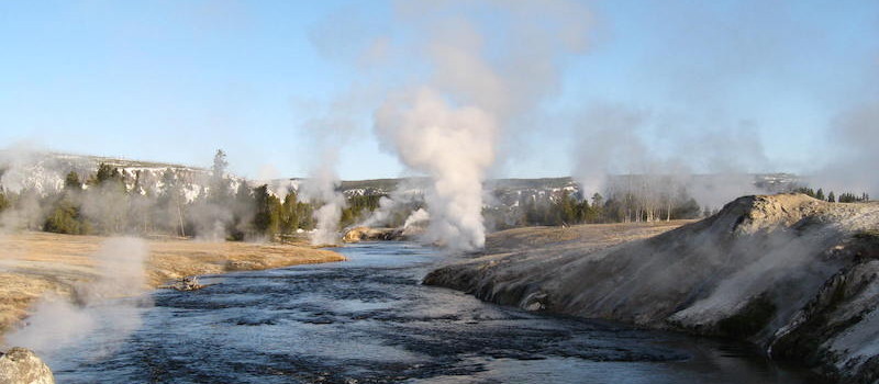
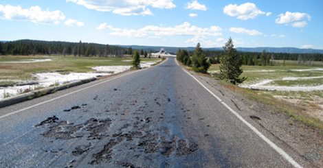
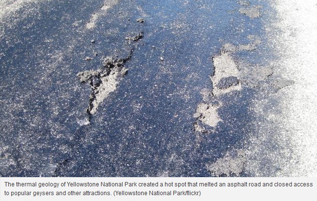
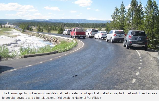
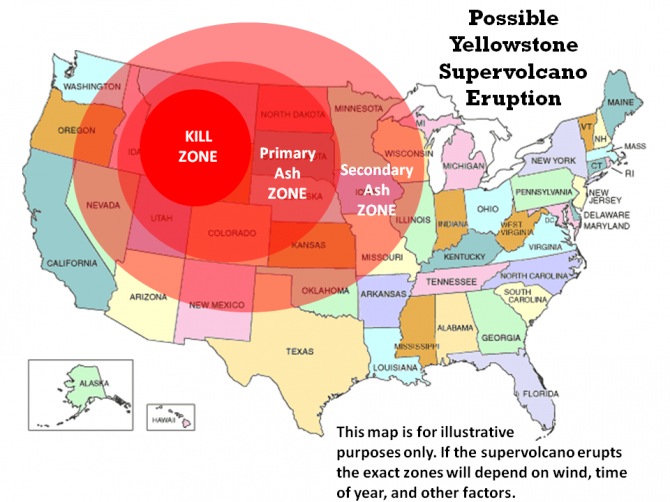
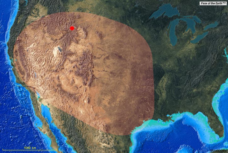
The super volcano near Yellowstone National Park in the western United States shows signs of activity « explosive » that could eliminate up to two thirds of the United States.
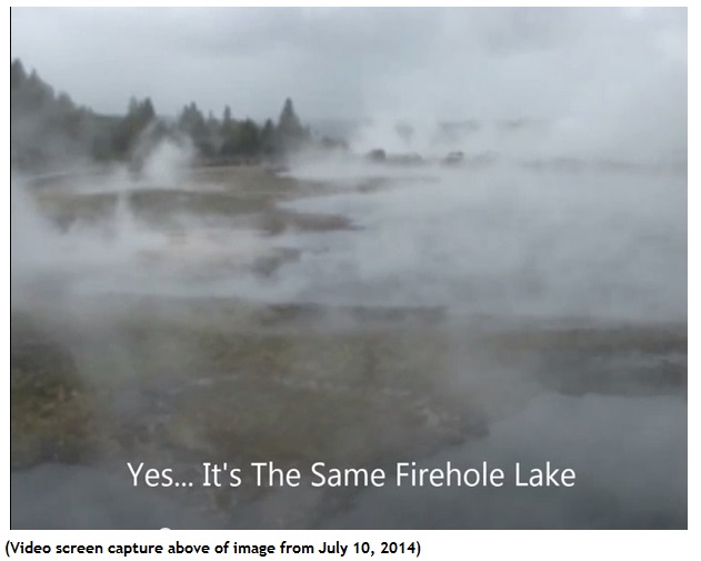
The ground is inflated by 20 centimeters over the past three years (since 2009), a record.Une supervolcano eruption once activated, two-thirds of the U.S. could become uninhabitable.
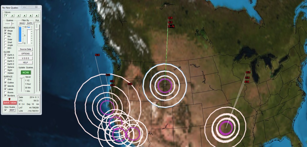
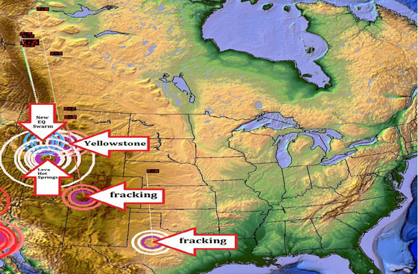
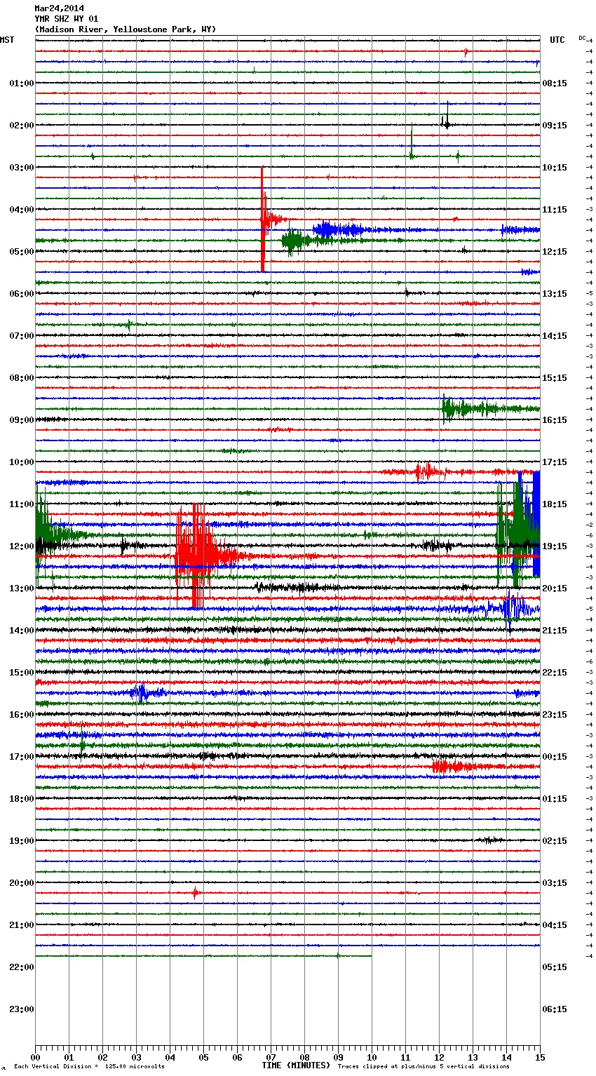
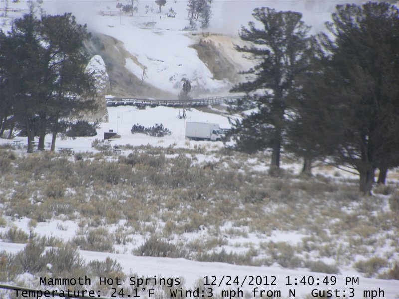
During the last two weeks (since the beginning of October 2012), more than 100 small earthquakes of moderate intensity per day, on average, have shaken the region of Yellowstone National Park, putting scientists who monitor the park’s geology state of alert.
If the volcano erupt …
A force a thousand times more powerful than the eruption of Mount St. Helens in 1980, a deadly cloud of ash, erase all living things by creating a layer of 3 meters within 1500 miles.
Two thirds of the U.S. could become uninhabitable by simply sweeping winds toxic air, and millions of people were forced to leave their homes.
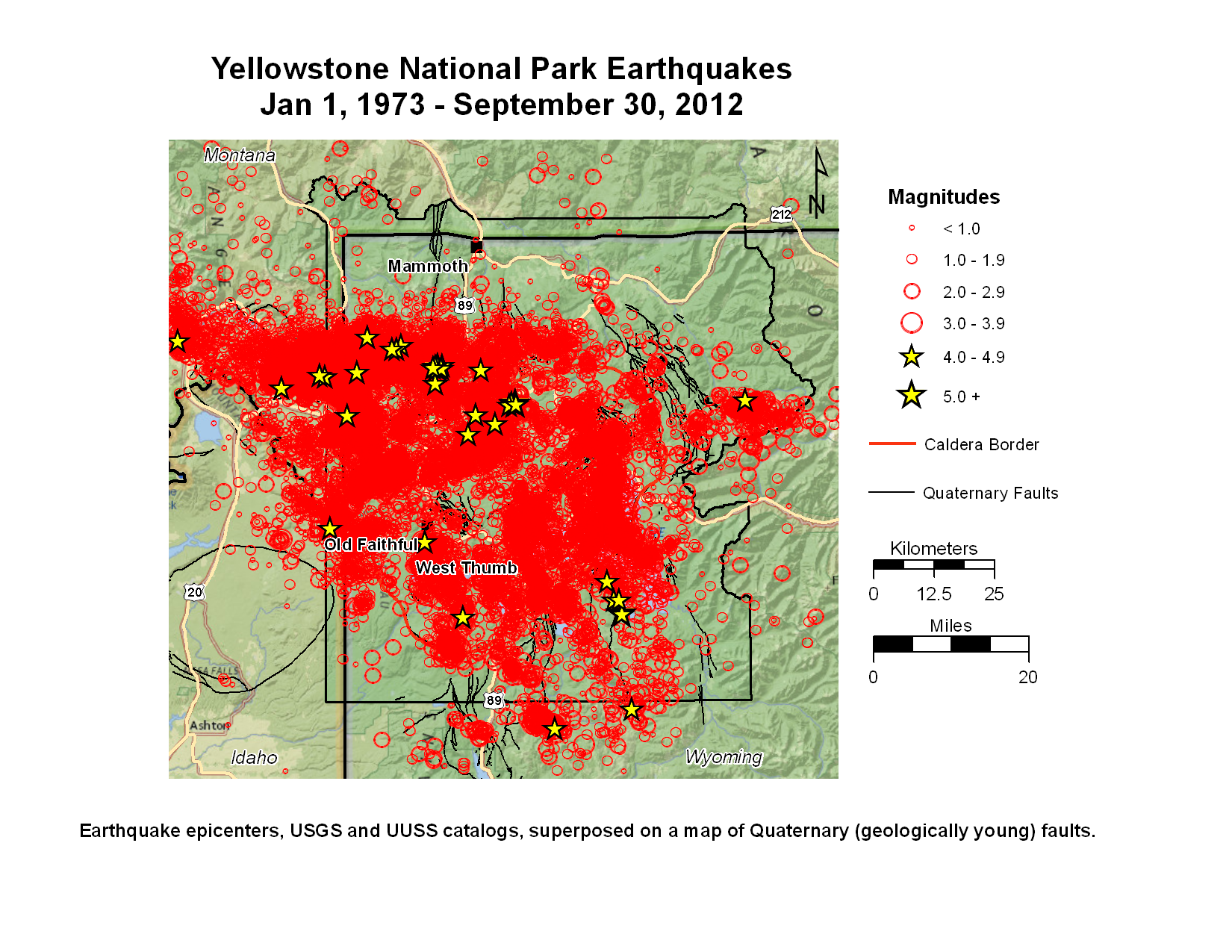
The caldera of Yellowstone National Park erupted three times in the last 2.1 million years. A trend in recent years has alerted the experts who closely follow the evolution of the volcano.
The super-volcano underneath the Wyoming park has increased its activity at a record rate since 2004. Its soil inflated at a rate of 7.5 centimeters per year over the past three years, the fastest pace since records began in 1923.
In the absence of other data, scientists are reluctant to give a warning and set a date for a hypothetical eruption.
An eruption of this volcano would far exceed the effect of the Icelandic volcano Eyjafjallajökull, which erupted in April last year, causing travel chaos around the world.
The expert in Yellowstone volcanism and professor of geophysics at the University of Utah, Robert Bob Smith, told National Geographic:
« This is an extraordinary scientific development because it covers a vast area and research costs are so high, that at the beginning we were concerned that this could lead to an eruption. »
In 2004, Rob Smith wrote:
« When we saw the magma was at a depth of ten kilometers, we feel more relieved. If it had been at depths of two or three kilometers, then the story would be different. »
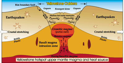
In 2012, with more efficient equipment and budgets, the great reservoir of magma was spotted six kilometers from the surface … and the thickness of the crust is very thin below Yelklowstone Park.
We are therefore faced with a sort of countdown to the whims of the cosmos itself.
Here’s why:
The consequences of the eruption of a supervolcano on Earth Humans
Toba, 74,000 years ago
The super-eruption of Toba (Indonesia today) occurred 74,000 years here gave birth to a lake in the caldera measuring 100 km long and 60 km wide. In short, it was a colossal explosion whose ashes were scattered over thousands of miles away.
Scientists are only beginning to understand the effects of the release of much volcanic ash in the atmosphere of the planet.
If we analyze geological samples found around the world on the ocean floor, and now carefully preserved at the American University of Columbia, you can find out what happened to the days when Toba erupted.
Professor Michael Rampino of New York University and studied the samples concludes
today that the size of the eruption of Toba was huge. We are talking about 3000 km3 of material that was ejected from the volcano. This represents approximately 10,000 times the size of the eruption of St. Helens in 1980 is considered one of the largest eruptions to this day.
The energy released by the great Toba eruption was equivalent to 1 GT of TNT, or about 67,000 times the Hiroshima bomb. This is a VEI August 10 times more intense than the minimum, producing effects similar to that of an asteroid at least 800 m in diameter on a granitic soil.
A 2500 km from Toba retouve on the ocean floor in a layer of ash 35 cm thick which was deposited immediately after the eruption. It reveals that Toba caused a super volcanic event of a power far greater than all other volcanoes known until today.
The ash analysis revealed that the eruption was rich in sulfur and have released a huge amount of sulfur dioxide and other gases into the stratosphere, where they are fallen aerosol acid compounds sulfuric affecting the Earth’s climate over the years.
June 12, 1991, eruption of Mount Pinatubo in the Philippines caused a decrease to 0 .5 degree Celsius global scale.
Following the eruption of Mount Pinatubo in 1991, we know that the ashes transported to the stratosphere, over 18 km altitude at that latitude, have obscured the sunlight and caused a cooling of the climate scale World. The year after the eruption, we indeed witnessed a drop in average global temperature of 0.5 ° C.
By comparing the amount of material ejected by Pinatubo but also St.Helens (IEV 5), Krakatoa (IEV 6) and Tambora (IEV 7), Rampino assessed the temperature drop caused by Toba at 5 ° C. .
On the scale of global climate, a drop of 5 ° C is a global winter. High latitudes (50-70 °) this is a cool 15 ° C during the summer months: Europe supporting 30 ° C as 40 ° C in summer would fall snow in July, there would be a volcanic winter. Effects on agriculture, the growth of plants and ocean life would be catastrophic. This winter time when England, Scandinavia and Canada will experience a polar climate is expected to continue for years with a fatal blow to many living beings, animals and plants.
But what would be the impact on humans? The answer is unfortunately not in the rocks. We can get an idea if we go back to the time when Neanderthal man had to face the coldest 75,000 years ago, during the Würm glaciation that lasted more than 20,000 years. But these are indirect evidence (rock shelters, animal skins and some other utensils coarse).
You can learn more if we stay in Canada, the Scandinavian countries and Central Asia in winter is about the climate of Western Europe would have to bear during a volcanic winter, but with much smaller resources and knowing that these climatic and economic conditions harsh last throughout the year. When I spoke in a cold sweat, this time it is much more concrete …
Mitochondria help anthropologists
Having learned that ecological disruption, two professors specializing in human genetics at the University of Utah, Lynn Jorde, a geneticist at the School of Medicine and Henry Harpending, an anthropologist, has linked this event to the issue of genetic evolution Mitochondria , one of the oldest organizations today and fully integrated human biology.
By analyzing the mutation rate of mitochondrial DNA in ages, Harpending and Jorde noticed a strange phenomenon emerged from their results. It is expected to observe a relatively constant population size, with local peaks of growth and periods of stagnation or even decline, including mixtures of population. But they observed that the human population had decreased to frankly some time.
This observation confirmed that other geneticists thought already. It has long wondered why humanity today presented a genetic variant containing so little when he was so rich to begin with? Phenomenon which might well have been the cause of this trend down? There is indeed all human societies today, whether they live in Africa, Europe, Asia and America have virtually the same genetic heritage so that within a hundred thousand years we should get genetic diversity is much more abundant genetic combinations. What could be the cause?
The answer is that there was a dramatic decrease in population somewhere in the past. Scientists event there are less than 100,000 years: a bottleneck occurred for reasons that remain to be discovered.
The human DNA is so similar across populations today that scientists have concluded that there was certainly a catastrophic reduction in population in the past. How imagine it?
Harpending take the example of the current population is about 6 billion people. The event happened corresponds to almost total extinction where only a few thousand survived. In fact our species was on the verge of extinction.
But a corollary it speaks also to our evolution. In an extraordinary diversity prior to the eruption, our ancestors would have gone through a bottleneck which would explain the poverty of our genetic heritage today and fragility. Concretely, this means that we all descend from the same family.
According to Lynn Jorde, mitochondrial mutations are carried out with great regularity and the number of mutations can serve as a genetic clock to date the major events. In the case of our throttling Harpending and Jorde felt that occurred here 70 or 80 thousand years.
Remains to be seen how this event has caused major mortality which left on Earth that 5 or 10 thousand survivors?
Until now, geneticists had no idea what could have caused this accident. Henry Harpending began a lecture series in American universities to discuss this « bottleneck ». It was on this occasion he was invited by prof. Stanley Ambrose, a paleoanthropologist at the University of Illinois to give a lecture to his students.
It is by reading the history of the human population bottlenecks and asking that she might be the cause Ambrose found the explanation. He communicated his idea to immediately Harpending who read his message a week later. Ambrose spoke of the great eruption of a volcano called Toba in Sumatra …
As we have said, the research team went on the assumption that the strangulation occurred between 70 and 80 thousand years, although this date is still widely debated. The super volcano Toba erupted 74,000 years here, right in the middle of this period. The super-eruption of Toba would have led to the extinction of most human beings.
Remember that at this time the man had already conquered most of submerged lands in Africa, Europe, America and Asia, and this year 500,000 people were already several million people. Before the explosion is believed that hundreds of species of hominids branched and more or less affiliated lived on Earth. After the explosion a single species would have survived, which led to Homo sapiens.
If the two events are connected vraiments, this has implications on the future terrifying eruption of Yellowstone. Its eruption could be of the same magnitude as that of Toba and have a devastating effect, not only on the surrounding region, but all over the Earth.
Scenario Yellowstone super eruption
Michael Rampino, the Yellowstone super eruption was between 1000 and 2500 times more powerful than Mount St. Helens, a power that Yellowstone has implemented in the past.
Imagine over 1000 volcanoes like Pinatubo or St.Helens erupted simultaneously entering … The explosion release into the atmosphere between 1000 and 2500 km3 of ash and volcanic material. Incandescent magma blocks of several cubic meters fall on the ground at supersonic speed. In a few minutes hundreds of thousands if not millions of people will die in the United States instantly incinerated, pulverized. Large fertile plains are covered with ash.
If this happens in winter ashes mingle with the snow to form streams of mud, even more devastating lahars because of their high density and their higher inertia. In a few days the ash cloud will reach the Gulf of Mexico.
The transport of the blast in the upper atmosphere billions of billions of tons of ash, dust and sulfur dioxide which gradually darken the sunlight.
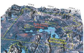
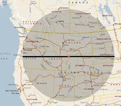
Extension of the two previous eruptions of Yellowstone. 2/3 of the United State are affected. This could he reproduce? Scientists think. Prepared by Dan Brennan and Mary Diman / UW-Madison News Graphics, translated and adapted by the author. All rights reserved.
The climate will be altered on a global scale in the space of a few months. We will undergo continuous volcanic winter will last several years. Crops will be destroyed for several seasons even for several years, and especially wheat reserves of the United States who are now the breadbasket of the entire planet.
The economic crisis is catastrophic and it will probably a generation or two to see life reborn, half a century during which deprivation of life will be extremely painful for everyone!
The pessimists predict that this event will be fatal for humanity because there will be no resources available with all the excesses that this social cause. If this theory seems to be confirmed by the events of the past, some scientists oppose this conclusion deemed too Ardie. For our survival, hope they are right.
If this theory is correct, and it seems subsequently confirmed by several separate events, we can better understand why scientists had cold sweats when they learned that was not only a Yellowstone super volcano, but he was ready to wake up … A story that could lead to the 6th extinction, that of humanity … and a very high percentage of other forms of life on Earth.
Given the state of the planet after the disaster, it might be better if we disappeared in the eruption, because I’d rather keep the memory of green grass and blue sky punctuated here and there, cumulus beautiful time rather than see dry grass, dead trees gnawed by sulfuric acid, a gray sky out of sight and have to live the rest of my life in the cold and artificial lights! … But let us hope, the earth has already experienced such disasters and man has always maintained its survival instinct.
Also, as Defender of the Earth, I propose ways to ensure a minimum of people can continue the extraordinary adventure of Humanity … on Earth or in outer space!
By joining together in abolishing war, trying to change the vision of humans on Earth, we will succeed in the future, despite the disasters that threaten us, to realize that we have failed in the past or live united in the harmony of all our communion with ecosystems
all life forms who share our beautiful blue planet … Earth … Gaia!
by Michel Duchaine ,
founder of the Defenders of the Earth
Truthseeker and Truthteller
PS
This article will become a new video…on our World Audiologic Network…on this link: http://WauN.onlc.eu
Bienvenue à tous et à toutes:Nous venons de lancer une nouvelle boutique indépendante du site afin de nous aider à rentabiliser notre site Michelduchaine.com
Vous trouverez de nombreux articles vintage et de collection diverses au fil des jours.
Elle vous permettra d'acquérir des articles venant directement de Michel...D'aille elle s'appelle "Vintage par Michel que vous trouverez sur ce lien:https://www.etsy.com/ca-fr/shop/VintageParMichel?ref=seller-platform-mcnav Ignorer