
Flash **** indicios de grave terremoto / erupción en el Parque Nacional de Yellowstone
FLASH *** *** INDICACIONES DE GRAVES DEL TERREMOTO / erupción del Parque Nacional de Yellowstone
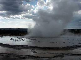
Domingo, 02 de febrero 2014 05:06 – ( TRN) – Un sismómetro dentro de un pozo para el Parque Nacional de Yellowstone comenzó a tambalearse cerca de la esquina suroeste de la actividad subterránea de Yellowstone Lake, posiblemente marcando el inicio de una erupción del volcán en el Parque Nacional Great Yellowstone. TRN tiene la imagen del informe de sismógrafos y ahora se puede ver por sí mismo ! Esto podría ser muy malo. . . El lago Yellowstone es más o menos en el centro de la cual es la caldera de Yellowstone , . la boca de un volcán supermasivo ubicado debajo de la actividad del parque comenzó alrededor de las 12:00 pm, hora estándar de la montaña (MST ) el 1 de febrero, y fue detectado por un sismómetro en la perforación B944 luego continuó sin parar, todo día de ayer empeorando mientras las horas pasaban. La actividad continúa en este momento a 06:06 AM EST como ocurrió este reportaje . El siguiente mapa muestra la ubicación de los agujeros de perforación en relación con B944 Yellowstone Lake y el resto del parque. Las lecturas deben ser reportados dentro de sismómetro en el interior del agujero de perforación # B944 son , literalmente, » fuera de la escala. » Es un terremoto de elaboración de la cerveza , o es el inicio de una erupción catastrófica del Yellowstone « Super Volcano ? » Parque Nacional de Yellowstone seismographic Impresión , Taladro # B944 , durante el 01 de febrero 2014 . La marca de tiempo por el borde izquierdo . Mira lo que comienza a suceder a partir de 12:00 para el resto del día . Por 15:00 MST , las cosas se ponen realmente arriesgado, antes de las 5:00 , está claro que existe una dificultad real que está ocurriendo bajo tierra. Por 19:00 , el tren está totalmente abrumado seismographic , con todas las lecturas son completamente fuera de la escala . Esto podría ser una señal de que una erupción masiva de Yellowstone súper volcán entró en profundidad. HAGA CLIC EN LA IMAGEN PARA VER DOS VECES MAYOR Una segunda edición se presenta la actividad continúa hasta este mismo momento, tan severamente que la impresora sismómetro se está quedando sin AZUL, NEGRO Y TINTA VERDE! Aquí la actividad de la medianoche hasta las 4:30 MST MST ( 05:30 EST) CLIC EN LA FOTO PARA DOS VECES MAYOR EN LA PERSPECTIVA enormidad YELLOWSTONE Para ayudar a los lectores a entender las implicaciones de lo que ocurre , se muestra en primer lugar, la escala nacional de Yellowstone » » park « , con las estadísticas de los EE.UU. Servicio de Parques Nacionales : • Yellowstone fue el primer parque nacional del mundo • Una Reserva de la Biosfera declarada Patrimonio de la Humanidad designado • 3.472 millas cuadradas • 8.987 kilometros cuadrados o 2.221.766 hectáreas o 898.317 hectáreas • 63 millas del aire de norte a sur (102 km ) • 54 millas de aire de este a oeste 87 km) • 96 % en Wyoming • 3 % en Montana • 1 % en el Idaho • punto más alto: 11 358 m / 3462 m ( Pico del Águila ) • punto más bajo: 5282 m / 1610 m ( Reese Creek) • Más grande que Rhode Island y Delaware combinados • Alrededor de un cuarto de del tamaño de Suiza y alrededor del 65 % del tamaño de Montenegro • Aproximadamente el 5 % del parque está cubierta por agua , el 15% es pastos y el 80 % de los bosques • las precipitaciones de 10 pulgadas ( 26 cm) en el límite norte 80 pulgadas ( 205 cm) a la esquina suroeste • Temperaturas (promedio) Mammoth : enero: 9 ° C / -13 C en julio : 80 ° F/27 C • Registros : Máx : 99 ° F/37 C 2002 ( Mammoth ) baja temperatura : -66 ° CF/-54 ( entrada oeste , Riverside estación de 1933 ) es un mapa de Yellowstone .. Aquí está un mapa topográfico que muestra la boca ( » Caldera « ) super Volcano y cicatrices , traicionero terreno , creado por el pasado ( Haga clic en la foto para ampliar ) límites del parque erupciones son delgada línea amarilla Caldera súper volcán está representado por la delgada línea roja . Tenga en cuenta que B944 sismómetro está justo al lado de la zona denominada » West Thumb » en el mapa que muestra el extremo occidental del lago Yellowstone. Esto pone a la actividad sísmica justo en la zona activa de la caldera real. Un reciente programa transmitido por la British Broadcasting Corporation (BBC ) ****** teoría de que una erupción de Yellowstone afecta . Por debajo de la ****** explosión TEÓRICO , daños y área volcánica caída de cenizas , que se representa en varios tonos de naranja . (* Esta imagen no se corresponde con una erupción en curso – que no es real ) Si este es el comienzo de una erupción en Yellowstone , mientras que el cuadrante noroeste del país podría verse afectada por los daños y la interrupción – más allá de la comprensión humana. Vamos a seguir de cerca esta historia.
fuente:Fuente

