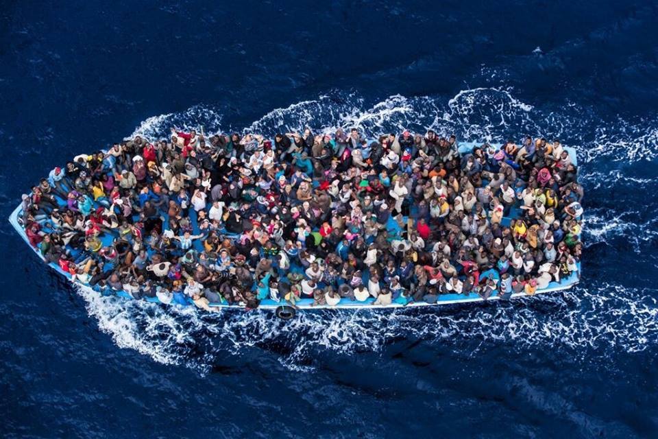
Qu’est-ce? Des milliers de migrants syriens et africains en essayant d’atteindre l’Europe. Beaucoup perdent leur vie, en particulier les enfants. Qu’en est-il de cette image? Il pourrait être moi! Ce pourrait vous ou votre famille ! Ou en sont les règles de notre humanité? Elles ne sont pas dans les mains ,ni dans l’esprit de nos gouvernements,mais dans l’esprit et le cœur de toute l’Humanité elle-même,car nous sommes Un!
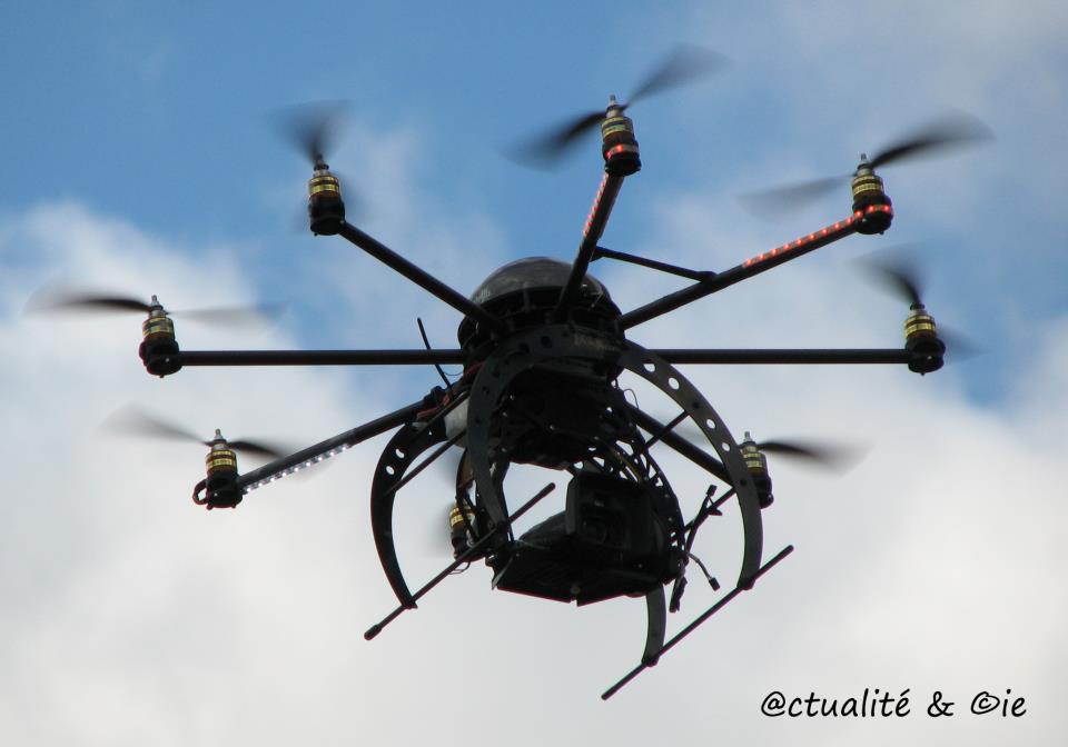
Un drone de surveillance civile (urbaine).Comme si on ne dépensait pas assez au Québec et au Canada,voilà qu’on nous espionne à coût élevé alors qu’on nous met un budget d’austérité sur le nez.
Contestés, mais sur le point d’être achetés. Les Forces armées canadiennes viennent d’exprimer officiellement leurs intentions d’acquérir, dans les prochaines années, des drones armés pour leurs opérations militaires. Ces avions sans pilote, utilisés par les Américains en Afghanistan et Irak, entre autres, font régulièrement la manchette en raison des nombreux civils qu’ils entraînent dans la mort. Le Canada cherche toutefois par cette acquisition, évaluée à entre 500 millions et 1,5 milliard de dollars, à moderniser sa philosophie de la guerre, tout en alignant ses pratiques sur celles de son voisin du Sud. De plus en plus,la liberté et le droit d’exister disparaissent…
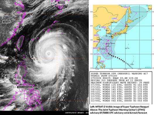
Le 7 juillet 2014,alors que le super typhon est sur le point de devenir un cyclone de catégorie 5/5, le Japon est déjà en alerte maximale. Un responsable de l’agence de météo a prévenu que Neoguri, pourrait atteindre une violence quasi inédite. « Soyez prêts à l’évacuation ». Sur Okinawa, il s’agira du plus violent typhon annoncé sur l’île en 15 ans.
La photo d’un groupe d’Israéliens, réunis pour regarder les bombardements opérés par leur pays sur la bande de Gaza comme s’ils suivaient un match de football, a provoqué un tollé sur Twitter. La photographie a été prise à Sderot, une ville israélienne proche de la frontière avec Gaza, et publiée sur Twitter par le journaliste danois Allan Sörensen qui travaille pour le quotidien Kristelig Dagblad. « Cinéma de Sderot. Des Israéliens apportent des chaises au sommet d’une colline de Sderot pour regarder les dernières nouvelles de Gaza, applaudissant quand des explosions se font entendre« , a-t-il écrit comme commentaire. La photo a été retweetée 8 000 fois et a suscité une controverse internationale. « Que Dieu nous vienne en aide si c’est vrai », a réagi une personne sur Twitter. « Qu’est-il advenu de l’humanité ? » ; « L’image la plus horrible que j’ai vue ces derniers jours », a déclaré une autre. « Inhumain, méprisable et nauséabond », juge une troisième. Souvenez-vous, il y a quelques mois, une vidéo avait déjà été prise à ce même endroit, dans laquelle on voit des auto-élus nous expliquer à quel point ils trouvent formidable de venir regarder les Palestiniens se faire bombarder. En 2012, François Hollande déclarait : « Israël est très critiqué car c’est une grande démocratie ». Il y a quatre jours, 9 juillet 2014, le site officiel de l’Élysée publiait un communiqué dans lequel on apprenait que la France soutient totalement Israël. Quelle sera la prochaine étape ? Hollande bientôt assis à coté des sionistes sur les chaises longues pour contempler les bombardements ?
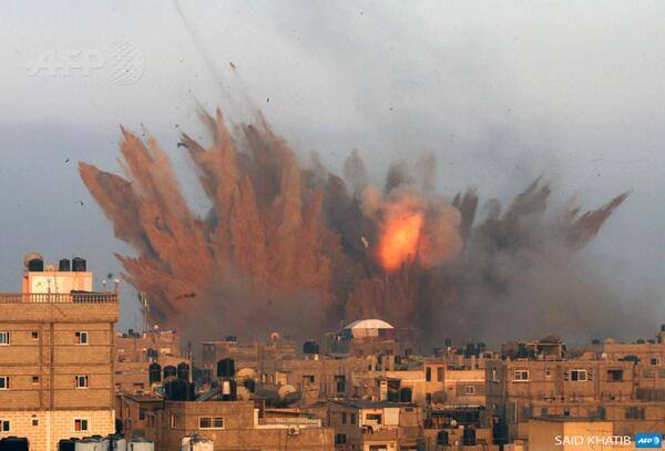
Gaza bombardée par les avions de l’état sioniste d’Israel,le 12 juillet 2014.Ce sont ces images qui font la délectations des sionistes assis devant leurs télé. Gaza est l’un des territoires les plus surpeuplés au monde.Dire que l’on bombarde Gaza pour atteindre le Hamas est de l’irresponsabilité pure.
Avec l’arrivée de l’OTAN en Afghanistan ,la production d’opium a augmenté de 40% et les profits de 700%…les mercenaires d’Al Qaîda sont puissants et riches,seuls les profits comptent.
Le grand empire …chambranle.
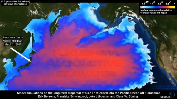
Rien ne fait barrière aux 400 tonnes métriques d’eau radioactive qui se jettent quotidiennement à chaque jour.
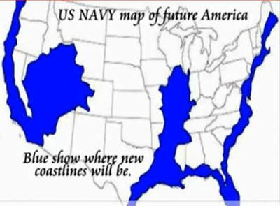
Map of flooding … depending on HAARP and the United States Navy
What’scurrently happeningon this planet andespeciallythe United States?
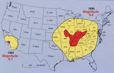
Thousands of birdsfall from the sky, dead!Tens ofthousands of fishwashed ashore, dead!Earthquakesare popping up inunexpected places. It turns out thattheNew Madrid faultiswaking up. Thisflaw issixtimes greater thanthat of St.Andreasin California.ItcoversIllinois,Indiana, Missouri, Arkansas,Kentucky,Tennessee andMississippi.
Thelargestearthquakes in thehistoryof the United Stateswere caused bytheNew Madrid fault.
Butnowit is fearedshewakesto becomemore deadlythan it wasalready.
Indeed,there are200 yearsin 1811and 1812, there were fouralmostconsecutiveearthquakesin the areaof the faultwith a magnitude of7 to 8.Theseearthquakescreateddeep cracksthat affectedthe course of theMississippiandwere feltto Boston.
The most recentearthquakethat struckthe regionwas that ofDale, Illinois in 1968.
Ifan earthquakeas announcedwere to occurtoday, cities such as St.Louis, Missouri andMemphis,Tennesseewould be totallydestroyed.
Jack M.Reed,geologist-geophysicist retiredfrom Texaco, hasclosely studiedthe geology of theGulf of Mexicofor over 40years.Reedis convinced thatthe Gulf of Mexicois currentlytectonicallyactive, and thatis the sourceof mostseismic activityalong theNew Madrid fault. According toReed,there issubstantial evidence thatthe area of theNew Madrid faultis directly relatedto « deeply buried tectonics » in the Gulf ofMexico….evidence
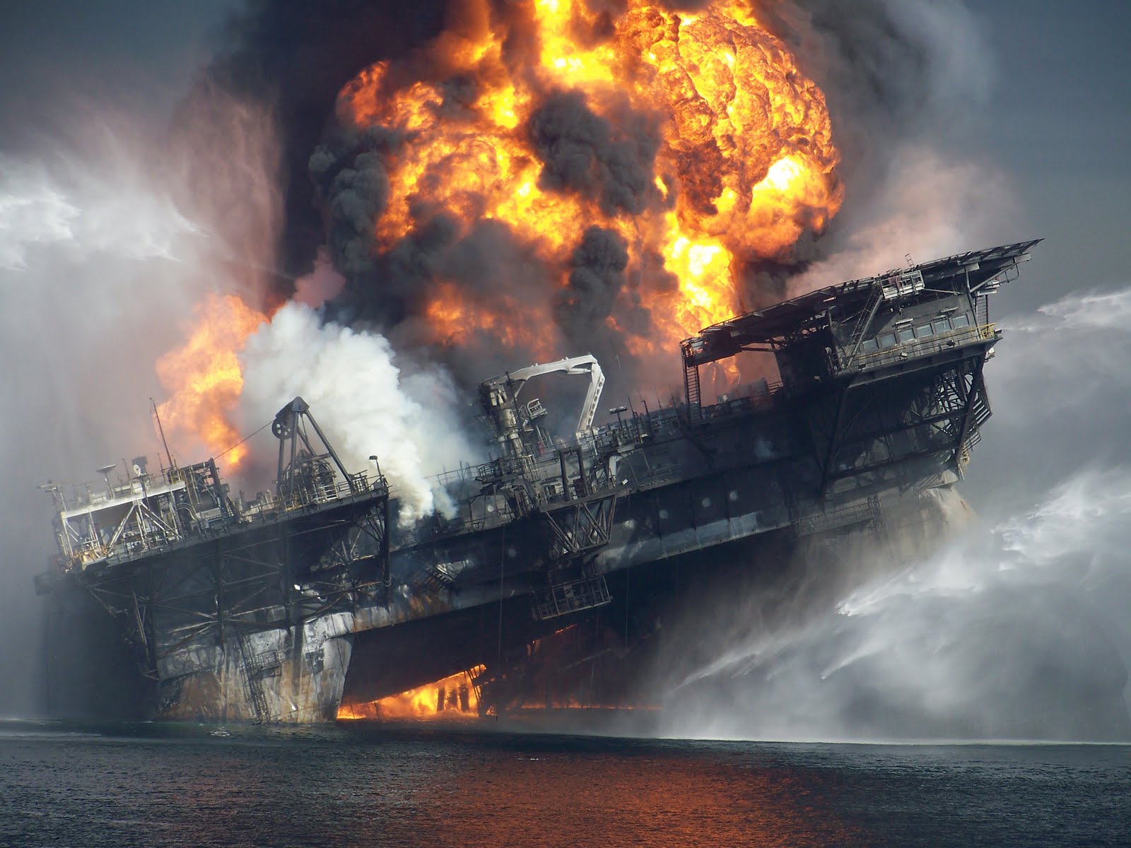
BPcouldcause damageby drillinginthe area of theGulf of Mexico… 1
Several newspapersrecently announced thatBPwasallowed to resumedrillingand evenstartnew wellsin the explosiveMacondoregionwhere the lastcatastropheoccurred. Yes, crazy corporate greedat the very least. WereportedApril 4, 2011:
Oil giantBPplans torestartdeepwaterdrillingin the Gulf ofMexicothis summerjust a yearafterthe Deepwater Horizonexplosionthat led to theworst oil spill inhistory.
The group hopes tostart work on10 wellsin the Gulfafter obtainingauthorizationby the U.S. authoritiesto continuethe interrupted jobwhendrilling moratoriumimposed afterthe spill.
The decisionis causepublic anger, coming just a yearafter the devastatingoil spillthat occurredwhen aBPwellexploded, killing11 workersandcausing anenvironmental crisis.
Fortdenied
This authorizationis reportedto have been givenby ajudge, butwassubsequentlydeniedcategorically, andarticles onthis authorizationseem to havebeen carefullyremovedfrom thenet.
Here is theofficial denial.
TheU.S. Department ofInterioron Monday rejectedmedia reportsaswhatBPwas en route toan agreementresumedeepwater drillingin the Gulf ofMexico, a year after the worst oilspill in U.S.history.Britishmedia said thatBPwas in talks withthe U.S. government torestartdrilling ofwellsless than a yearafter the explosionof theMacondoDeepwaterHorizon.
Do not worry, they’ll get theirpermission.It is« test the waters » so to speak.
The fact is thatthisis already
Every day millionsofgallons of oilare extracted from theGulfandthe Mississippi River basin, on the way tothe heart of thefault lineofNewMadridfromArkansasbackto Illinoisand Indiana.
Notonly do weextractoil andnatural gas, butthechimiquéewater is injected intotherock stratato release moreoil and naturalgas by a processcalledfracturing(« fracking »):
Hydraulic fracturing(called « fracking, » or « Hydrofracking ») is a process thatresults in the creationoffracturesin rocks.Thefractureis froma well drilledin pockets ofrock formationsto increase theefficiency andmaximumrecovery of oil andnatural gaswells.
Hydraulicfracturesmay be natural orartificial andspread throughtheinternal fluid pressurewhich opens thefractureand causes it toextend throughthe rock.Naturalhydraulicfractures,arevolcanicpits,grooves andfracturingbyice actionduring freezing weather. Fracturescaused byman byfluid injectionare starteddeep intoa wellboreand expandedin targetedformations.The spacingofthegapisgenerallymaintainedaftertheintroductionbyinjectionof aproppantintotheinjectedliquid. The proppantisamaterial based ongrainsof sand,ceramicor other particles, which preventthefracturesfrom closingwhen the injectionis stopped.
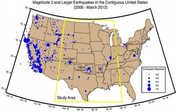
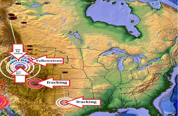
Map of earthquakes related to fracking in America.
The oil industryis a parasite thatdestroys theearthas wouldgiantmosquitosuckingbloodwhile injectingan infectedliquidinstead. Yes,the« invasion »is running andlong.
Environmental groupshave protestedagainstthishorriblepoisoningof groundwater, but in vain.This is the resultwhen a largeoil tanker isinvolved– everyoneisbuying;
Underminimalsupervisionof the federal government, a myriad of chemicals isinjected into the groundin the name ofenergy explorationin the West.Amongthese chemicals, biocides are considered to bea serious threatto public healthand the environment.
Hydraulic fracturing, knownas « fracking » or « frac’ing » for short,is the processabout 90 percentof oil wellsand gasin the United Statessufferfor easyextraction.Biocides areusedto kill microorganismsthat may interferewith other fluidsand methodsare used to stimulatetheextractionandprevent corrosion ofpipes.
In 2005, theoil and gas industrywas granted an exemptionto the « Act respecting the safety of drinking water, » which allows the injectionoftoxic fluidsdirectly intogroundwater withoutoversight by theU.S. EnvironmentalProtection Agency(EPA).Before the adoption ofthis policy, theEPAconducted a studywhich concluded thatfrackingis aminimal threat tounderground sources ofdrinking water anddoes not determinewarrant furtherstudy; the studyhasbeen criticizedboth insideand outsidethe agency.Despite the concernofpublic healthprofessionalsand landownerswho have been victimsofcontaminated waterthemselves (read the story of LauraAmos), the agency continued torequire a minimumregulation of the industry.
A little hard toimagine?
Not whenwe know whoare the controllersand how theyare directed.We speaknot onlybad people, greedy, but theintentionsofa lot ofthem areseriouslyevil. Not all,because severalare alldupeswilling to take thetrainroute.
Have prior knowledgeof the potential effectson humanlife and healthof our planet andstillmakepressure ongovernment agencies tocomply with theirdesires,ittakes more thangreed.Andunderlingsjust have tofollow.
Howthe earthquakecould be triggered
LineNew Madrid faultis listed in theredbox below, but it is assumedthat it extendsfarther to theGulf of Mexico.There wasseriousearthquakesin the past, most recently in theongoing storywasofa magnitude of7 and 8in1811-1812.
Earthquakesof1811-1812NewMadridearthquakeswereintenseat theplates andstarted withtwostrong earthquakesDecember 16, 1811. These earthquakesremain the mostpowerfulever tohitthe eastern UnitedStates.These events, as well as the seismic zonewherethey occurred, were namedin connection withthe city of NewMadridon the Mississippi,Louisiana Territory, nowMissouri.
It is believed thatearthquakeswere feltstronglyabout130,000 squarekilometers, and moderatelynearly 3million square kilometers. The earthquakehistory ofSanFrancisco1906, by comparison, wasfeltmoderatelyover about16,000square kilometers.
The following mapshows the range ofeffects mentionedabovein comparison withthe earthquakein LosAngelesin 1994.
The great earthquake of Charleston in 1895.
Reallyserious.This is due tothenature of the rockin thisregionthat transmitsenergy more efficientlyinthe LosAngelesand California.
Frackingcausesearthquakes
Emptyingof largecavitiesand cuttingthe basement, you can expect to getrepercussions. Especially if itis justalong aknownfaultline.
Concernedresidentsliving juston thelineNew Madrid faultinArkansasknow exactlywhat the« fracking » andhadthis to sayjust a few weeksago:
News:EarthquakesinGreenbrierArkansasincreasing at the samerate asnatural gas drillingandfracking!
Arkansas faces directly to the New Madrid fault.
Peoplein the region ofGreenbrierArkansasarecertain of one thing: thatdrilling andfrackingincreasedin their areaas well asearthquakes.A resident ofGreenbrier,DirkDeturckliveson a ridgebetweenGuyandGreenbrier. He looked at theplatforms.Once they haveincreaseddrilling andfrackingnearGreenbrier,earthquakesin Greenbrierbegan to increasein intensity andfrequency.« They really feeldifferently now. » Deturcksaid. He described thesensationaswaves rollingfrom below andwhenit hits, it sounds like a « boom ».
He believes thatthe injection wellhas a lot todo withearthquakes, but condemnsall activitiesincludingfrackingstationsand compressors.During thesnowstorm,Deturknoted thatallgas activitystopped: no compressors running, no drilling, nofrackingand noinjection.Guess what? He said heconsidered theUSGSdataand therewere noearthquakes inthree days ofsnow.
He alsonoticeda swarm ofsmall earthquakesTennesseeside of theMississippiRiveron the same dayas other moreimportantGreenbrier. He fears thatgas productioncouldtrigger a « big one » may belocated offtheNew Madrid fault. We hadmanyexpertsAGSthat thisinsurancewill probably never happen, but they always tell usto make plansforemergency preparedness. Interesting.
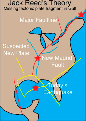
The Jack Reed’s theory.
The connectionbetween the Gulf andthe fault lineofNewMadrid
Herethe theory ofJackReed
JackReedis a geologist-geophysicist retiredTexacowho does not acceptthe widely held viewregardingthe lines ofNew Madrid faultora« passiveGulf. »
No wonder it isone of the fewvoices.Today, scienceis madeto stick to theneeds of business andpolitics,andnot the reverse.
According to him,the Gulfwas and istectonicallyactive–and it isnot onlylikely sourceof seismic activityin NewMadridseismiczonesbut alsoofMiddleton Place–Summerville near Charleston,South Carolina(August 2010)
« During all the yearsI workedin the basinof the Gulf ofMexicoI was forcedto accept thetheoryof the Gulf » passive « , which argues thatthe only movementin the basinissedimentarypileinupstreamsaltsmovedsouthward, Reed said. « But there is little evidenceto supportthis theory,and itdoes not matchwhat is observedgeologicallyorgeophysically. »
« This entire zone throughthe United Statessuffer fromsome typeof tectonic activitythatI believe isrelated to thedeeply buriedtectonicsin the Gulf ofMexico »
And they want tocontinue to drillthere?Yes I do.
The bulgeof methaneappearedafterthe explosion of theDeepwaterHorizonisdirectly in line withtheNew Madrid fault. And you thinkthey do not knowwhat they do?Reallyhard to believe.At leastthisiscriminalirresponsibility.
And now,the « GreatCentralU.S.shakeout« ? (drive earthquakeexercise,see HERE)3
So whiledrillingcontinuesofficialsare preparing torescue drillsin case.Go figure.
They even havea website.Surreal.
Twoexercisesearthquake preparednessin Indiana,the « GreatCentralU.S.Shakeout » scheduled forApril 19, anda training programin May tomanagement agenciesandemergencysolutionsreceiving increasedinterestafter the devastating earthquakeJapan.
The people ofIndianahave good reasonto prepare.Experts sayit isonly a matterofnotifbutwhenIndianawill be shakenby amajor earthquakeon theNewMadridseismic zoneorNewWabashValley.
TheCUSEC(centralconsortiumforU.S.earthquakes)said: « The probability of an earthquake of magnitude6 or greaterinthe central UnitedStatesis quite significant inthe near future, with a chance of 25 to 40percentoccurin anyperiod of50 years. An earthquake with amagnitude of 7to 8,theconsortiumwarned, « couldcause greatloss of lifeand property damagein the billions ofdollars. »
Anddrilling continues..
And soonagainin the volcanicarea ofMacondo. (End of Article)
Before continuinghere is ascreenshot of thefamous siteCUSEC.
CONCLUSION You should know thatit is theZionist Jewswho areat the head ofthis monstrousstrategy. They want to destroyhumanityfor the simplereason that theyare justfor that.It is theirmission andtheir onlyreason for being onEarth. Again, I repeat ALLinALL AREASHAS BEENREVERSED. YOU MUSTBECOME AWARETHATEVERYTHINGHAPPENSON EARTHISCURRENTLYSPONSORED BYTHEZIONISTJEWS, ALLIES TOILLUMINATIWHICHLEADSTOTHELISTROTSCHILDROCKEFELLERANDWHICHI WILL GIVE YOUTHE EVIDENCEOF THEIRJewishnessINNEXTARTICLEONMONSANTO. Ido not know ifHAARPis involved in theJapan disaster(tsunamiofMarch 11, 2011), but the thing Ido know isthat the JewshateJapan. Bycons, HAARPwas veryinvolvedinHaiti. And I canalsotell you that theIsraeli securitycompaniesnow controlmore than 70% of prisonsandthe electronic andnuclear systemsof theU.S. Army.
The ground begins to overheat in the large caldera. The worst is feared.
Plus on s’approche,plus le constat de danger est grave./ The closer you get, the more serious finding of danger. /
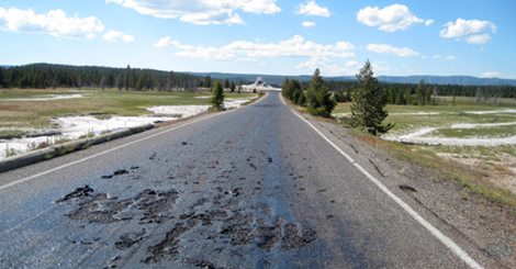
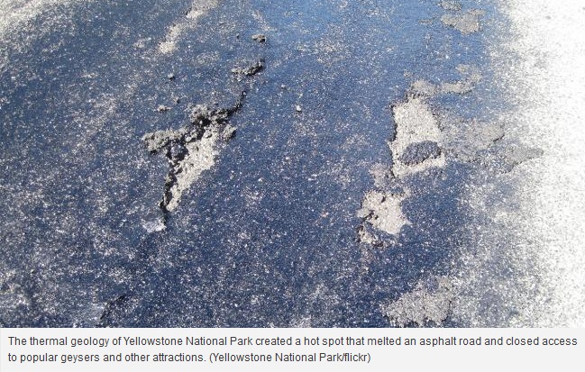
Melting the asphalt is very visible in this picture.
CHEYENNE, Wyoming (AP) –ThegeologyheatevolvingfromYellowstone National Parkhas createda hot spotthat meltsa paved roadand gatedaccess to popularattractionsandthe heightof the tourist seasongeysers,indicatedofficialsThursday, July 10, 2014.
Asthey examinedall possiblesolutions, park officialshave warnedvisitorsnot togo hikingin the affected area, where the dangerof walkingthrough the solidground,like watchingboiling waterwashigh.
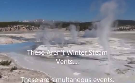
For several days, everything was starting to go slow. /
« There are many other placesto seeexcellentthermalfeatures inthe park, » said spokesmanAlNashYellowstone. « I do notwant to riskinjuryduringthis temporary closure. »
The closer you get, the more serious finding of danger. /
« Naturally, » say officials,changes in currentthermal characteristicswill oftendamage roadsand sidewalksYellowstone.Thesteamingpotholesinasphalt roadsand parking–defined bytraffic cones –arefairly commonsights.
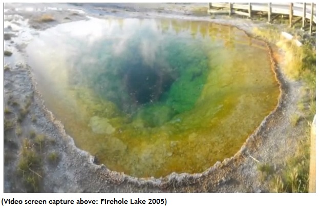
There is Firehole Lake in 2005.
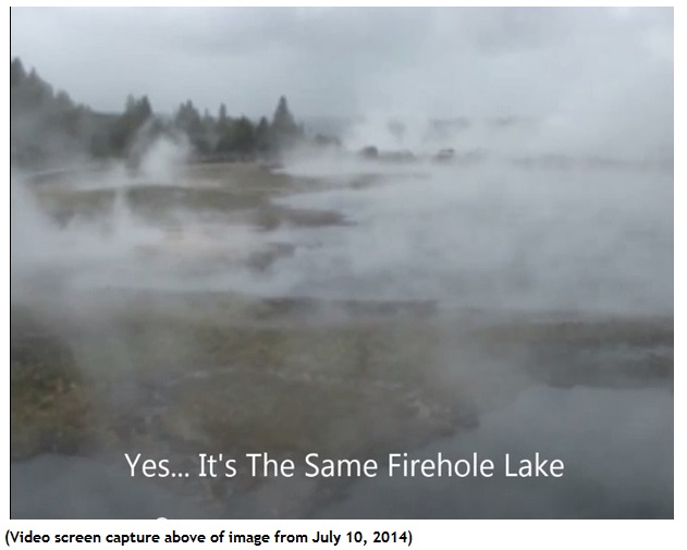
…and now ,there is his actual aspect.
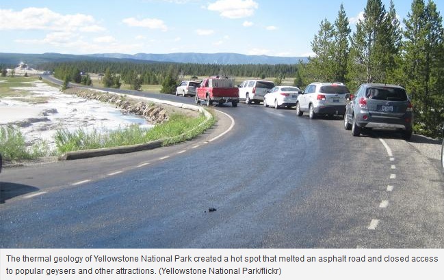
However, damage to FireholeLake Driveare particularly seriousand maytake several days tofix everything.3.3mileloopsixmilesnorth ofOld Faithful, is the roadthattakesvisitorsto see theGreat FountainGeyser,White DomeGeyserandFireholelake.
The weather isunseasonably warmforYellowstone –with highin themid-80stemperatures–has helped transformthe road ina warm,sticky mess.
« We have someideas.We’lltry.Our maintenancestaff reallylooked at the issue, » said Nash…which clearlyseeks to reassureus.
OTHERSONSOFBELL
The roadwas badly damagedby theextreme heatinYellowstone National Park, forcing park officialsto closeaccess. TheFireholeLake Drivearealooks like this:a fusion ofheat.
Park officialssaid in apress release thatthe extreme heatof the surroundingtemperature zonescausedasa thick oilbubblesrising to the surface, damaging the bitumenand creatingdangerous driving conditionson the popularandpicturesqueroad neartheGrandLooproadhalfwaybetween OldFaithful andMadisonJunctioninlower Geyser Basinpark.
3.3mileloopusually takesvisitors toGreat FountainGeyser(GreatFaithfull), White DomeGeyserandFireholeLake.
A date forthe reopening of theroad has notbeen announced.
The reporthelpedthe renewedrumors thattheYellowstone caldera, known as VolcanoYellowstonesupervolcanoor, soonburstignition.
TomLupshu, awell-knownbloggerconspiracythat runs theBunkerreportjust posteda new videoclaimingthat the volcanocould explodesoon.Thisreport and thereporton the roadKTVQpress releasehas beenhighlighted bythe site of theconspiracybefore it’snews. « Update! MeltsroadtoYellowstone National Park, causing the closure » He said inhis usualsensationaliststyle.
However, thevideoalso focuses onLupshuscientistssay they have discovered. calderais 2.5 timeslarger thanpreviously thoughtnewsbrokein December 2013Watch the video onthislink. video
Renewedspeculationfollowingacyclethat explodedin March,after a videowas postedshowinganimalsfledtothe park asa « warning » that the volcanowas about toerupt.
The last majoreruptionis thought to haveoccurredabout640,000 yearsagoand sentashacrossNorth America.
BobSmithofthe University ofUtahsaid researchersdo not know whenthesupervolcanocoulderupt again. Two furthereruptions occurred, there is a 2.1 million years, andthere are 1.3millionmore years, Smith said.One theory is thattheeruptions occurthereevery700,000 years, butSmithsaid thatmore dataare needed to safeguardthis theory…untilfurther notice!
AUTHORITIESARE MADEREASSURING
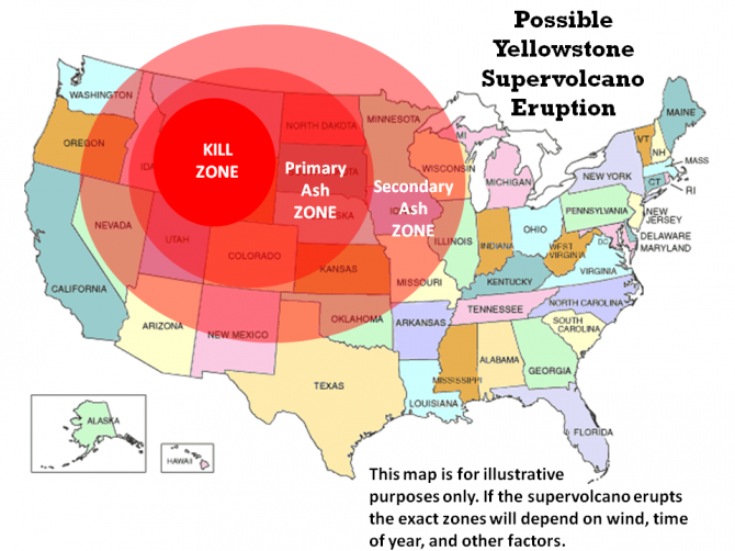
The death zone …around Yellowstone.
Une éruption du volcan de Yellowstone serait possible en 2014 ,selon certains chercheurs à la façon dont les animaux ont été repérés fuyant le parc national ces derniers mois.
Dans un rapport connexe par Le Inquisitor , il est affirmé que les récents tremblements de terre de Yellowstone ne déclencheront pas une éruption volcanique , mais les scientifiques ont reconnu que si un volcan de Yellowstone devait éclater le supervolcan résultant pourrait tuer tout le monde aux États-Unis:
« L’éruption du volcan de Yellowstone pourrait libérer suffisamment de magma et de cendres pour enterrer des villes entières sous des kilomètres de cendres. Les bonnes nouvelles sont que le supervolcan à Yellowstone n’est pas en danger d’explosion de sitôt. La dernière fois que cela s’est produit,c’ était avant l’aube de la civilisation. S’ils croient qu’arrêter une éruption est impossible, les scientifiques disent qu’ils devraient être en mesure de prédire une éruption en surveillant la pression du magma souterrain « .
Les tremblements de terre récents qui viennent de faire les nouvelles, mais l’ensemble de la zone gronde depuis le début de l’année 2014. Les graphiques de l’USGS montrent que les tremblements de terre supérieurs à 3.0 ampleur se sont produits loin et dessus pendant plusieurs jours et tous sont venus de la région de la chambre magmatique de Yellowstone, qui, selon un radar à pénétration de sol, s’étend à l’ouest jusqu’au la ligne d’état de l’Orégon.
Malheureusement, disent les défenseurs de la science officielle :certains théoriciens de la conspiration revendiquent que l’USGS essait de cacher la possibilité d’une éruption du volcan de Yellowstone se produisant actuellement,dans notre vie. Pour preuve qu’ils utilisent des vidéos comme celles-ci qui montrent prétendument …des buffles « courir pour sauver leur vie » loin du parc national de Yellowstone:
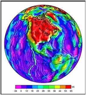
Map of the study of Russian scientists: a large magnetic anomaly on the American West Coast (orange yellow).
A grimreport prepared by theCommander in Chief ofthe Russian AirForce, Lieutenant-GeneralViktorBondarevon scientificmission whichhadjust completedoverNorthAmericamission carried outbyfourTupolev Tu-95, strategic airliftand 2IlyushinIl-78 tankersthat « by electronic scanning » for « magnetic anomalies »from Alaska toCalifornia, warns that a« catastrophic event » can be almostfor this region.
U.S. officials, it should be noted, described the missionas apurelyscientific« bombing run » that camewithin 50 milesof California,buttheir air forceswere able topushwith the launchof theF-15 combat.
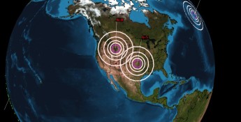
However, the reportindicates that thescientific missionwas necessitatedbya « seriousmysteriousmagnetic anomaly » detected by thesatelliteKosmos2473June 3, 2014, occurring in the Yellowstone region, west of the United Stateswhich ledwhat is calleda« swarm of earthquakes. «
Themost important thing tonote about the3 June 2014, Yellowstoneis this« magnetic anomaly », the report continuesthatsatellite measurementsshow that it isprecipitated by theswarm ofearthquakesthatmysterioushit theBrooksmountainRange, Alaska, andseismologistsare stilllooking forexplanations.
Information onthe binding of thesetwo « events » in this reporthave also beenverified bytheUnited States GeologicalSurvey (USGS) maps and data onthe magnetic anomaliesfor NorthAmerica showinga fieldmagnetic« perturbation/undulation » strangefromBrooksRangeand ending onJune 3Yellowstone.Lethese twoareas, it isimportant to note thatBrooksRangeis partof the Rocky Mountainsthat extendmore than4830 km(3000miles)in the northern partof BritishColumbia,in westernCanada, to New Mexicoin thesouthwesternUnited States.
« These are serious concernsforthe Russian military authoritieson these » events « , says GeneralBondarev‘s report, it was the » catastrophic effect « they had on advancedsystems »magnetoception« of inertialnavigationused by manyUS-NATO-Russian war planesthat use thesesophisticateddevicesinflight.
An important magnetic perturbation is on the road.
Although noRussian military aircraftwasnear the « magnetic disturbed area » fromourYellowstone,June 3, 2014, in this report,twoU.S. military aircraftwerewithintheir« frontier »in the southern regionCalifornia, June 4, while this« event »was still« active », making plantfloor,both.
The twoAmerican fighter planescrashedJune 4, 2014, the report said. Aircrafthave been identified asaU.S. NavyFA-183 crashedwhileattempting to landaboard theaircraft carrierCarlVinson,ajetandU.S. MarineAV-8BHarriercrashedin a residential areain Imperial,totheapproximately 90miles east ofSanDiego, the two accidents inthe same hours.
The reportnotes that nocivilian aircrafthave beenhit bythis « magnetic anomaly » that the mostadvancedmilitary aircraftusing thesesystemscoordinatedflight« geomagnetic planet » that allow them to « kiss the ground »is not withoutremembermagnetic systemsused by birdsand insectsto navigate.
ConcernsregardingRussia« magnetic anomalies », it is important to note, are related tothe magnetic north poleismoving rapidlysince 2005whichwas movedat a speed of40 kilometers (25 miles) per yearin the Canadian Arcticto Siberia.
A scaryindependent researchlast year(2013)alsowarnsthat this changeis accelerating, andyetaccording tothis researcheris expected toSiberiaat least2 years.
One effectof themagnetic north poleismovingquicklynoticedmostisthereportnotes: systemsairport runwayaredisturbedbecause of this, and we can readasan exampleof 2011thattook place in theStatesUSA:
« Tampa International Airport was forced toreadjustits runwaysThursday toaccount for themovement ofmagneticfields of the Earth, information thatpilots useto navigateplanes. Fromthefluctuationsof the force, the airport closed itsprimary runwayuntilJan. 13to changetaxiwaysignsto account forevolution,saystheFederal Aviation Administration.
The polesare generated bymovements withinthe inner and outercoreof the Earth,although the exactprocess is notexactlyknown. They are alsoconstantly in motion, moving a few degreesevery year, but the changes are almost neverof such a magnitudethatrunwaysrequireadjusting, said PaulTakemoto, aspokesman fortheFAA. «
The mostdisturbingreport of the Secretary-General Bondarevon these« events »areaspectsequationsit usesto postulate thatthisis happening nowin North Americawiththe« mysteriousmagneticanomalies »occurover a wide rangeofRocky Mountains,and when combinedwiththe rapidly changingmagnetic north poleandmore, it gives evidenceof global climate change, giving a « huge credibility » to what is called« the theory of Earthexpansion. «
The expansionof the Earth ormorethe hypothesis ofEarthexpansion, says the positionandthe relative movement ofcontinentsis at least partiallydue to the volumeof the Earthincreasinglyhighand standsunlike thatofplate tectonics, butnewfindings on« theories of the ether » and dark matter, General Bondarevsummary, this meansthat« seriousconsideration »should be givenundertheDavisUniversityCalifornie.Lecosmologist, Dr. AndreasAlbrechtwarned: « We have achieved somevery deepproblems withcosmology… allwithdark matter anddarkenergy,which tells us thatwe need to rethinkthephysicalbasic andtrysomething new. «
Orin simple terms,thisreport concludes: « We canbe on the vergeof a catastrophicNorth America » event « that could change the world forever, we must be ready. »
…………………………………………………………………………………………………………………………..
PHOTOGRAPHICEVIDENCE
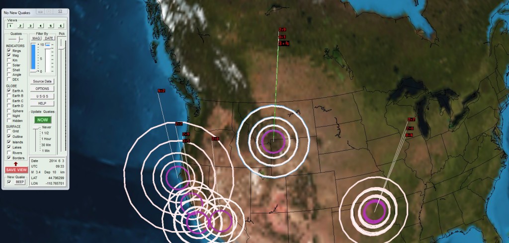
Graph showing the two major seismic epicenters.
The American West Coast (San Andreas Fault) Mississippi (San Madre Fault) and to Yellowstone … a great magnetic anomaly has occurred.
/ Operations fracking search for shale gas might even affect. Even capitalism contributes to the eruption of Yellowstone.
Brooks Range is at left at the top.
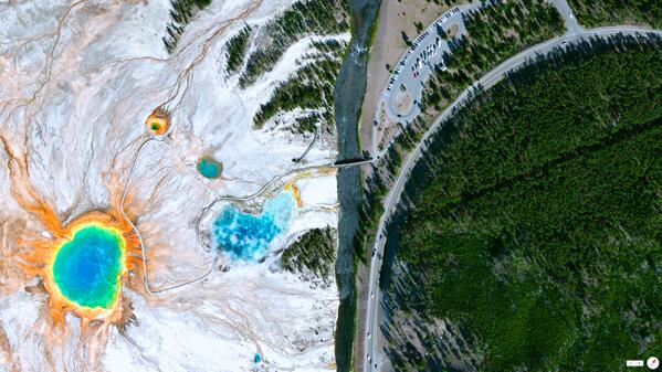
View of Firehole Lake from the sky.
Norris Basin,a bowling water.
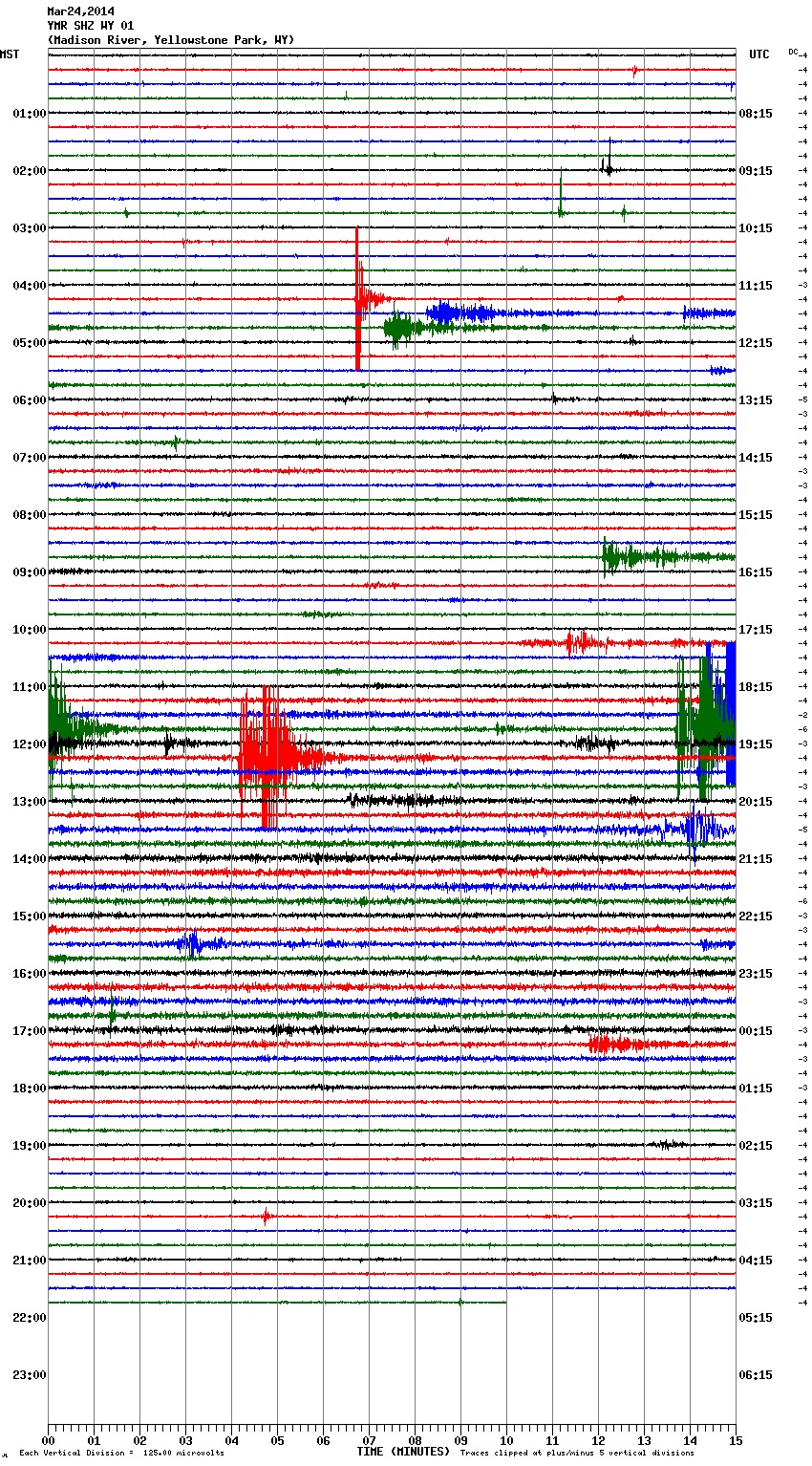
The earthquakes of March 24, 2014.
When the Yellowstone supervolcano will erupt, it will be the end of many animal species on Earth …
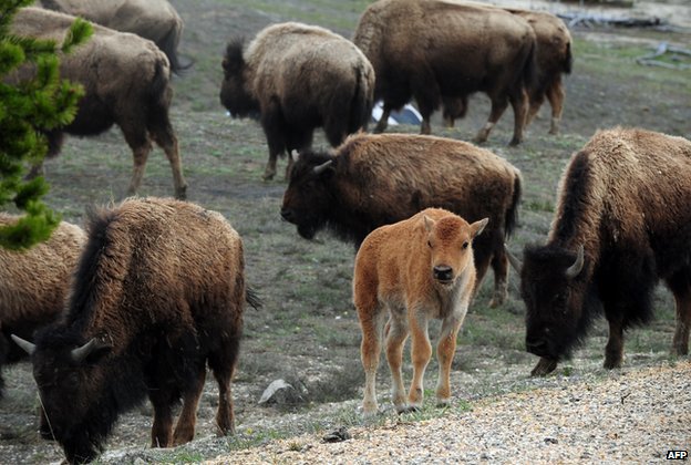
All my thoughts are with these great Bisons Park Yellowstone.Je wants them to live as long as possible.
UntilJune 6, 2014, the Indian continenthad not seenactivevolcanismduringthe last 60million years.On6 June 2014, a crackopenedin the groundnear the village ofGadiyainKangra districtof the stateHimachalPradesh, India. Flames,gas andvolcanicmagmacame outof aholefouryards wide, soil and researchersofficeof IndianGeological Surveyconfirmed thatmagmais, is the productionoflava thatcomesfrom deep withinthe earth andpiercedthe crust.
Recent picture of the event.
This is the first volcanic eruption ever seen in India, because the man was not there when the latter arrived there 65 million years ago at the end of the Cretaceous period.
The Deccan Traps marked the last, breaking the crust releasing a large effusion of magma in India. They are one of the largest volcanic provinces in the world. It consists of more than 6,500 feet (> 2000 m) lying basalt lava flows and covers an area of nearly 200,000 square miles (500,000 square kilometers) (about the size of Washington and Oregon combined) in the center West India. Estimates of the original area covered by lava flows are as high as 600,000 square miles (1,500,000 square kilometers). The volume of basalt is estimated at 12,275 cubic miles (512,000 cubic km) (1980 eruption of Mount St. Helens produces 1 cubic km of volcanic material). The Deccan Traps flood basalts are similar to basalts of the Columbia River in northwestern United States. (Source)
The giant eruption of Deccan threw so many gases in the atmosphere, is suspected to have played an important role in mass extinctions.
Parliamentary Secretary Jagjivan Pal, in the district assembly Sulah and falls in the region, visited the place this Tuesday, June 10, 2014. He said flames and hot liquid from the hill had created the panic.
« The temperature in the region has increased significantly in the basement and people say an electric steel pole had become bright red, there a few days, » he has said. Pal said that a material such as sulfur black stone appeared and flows outside the perimeter of the hill. (Source)
The outpouring of lava and gas continues to flow and the villagers are informed that they may lose their home if it continues. The nearest village is only 90 meters from the square.
The eruption of Deccan like India and had a profound effect on the whole planet, hope this is not the start of something much, much more.
The Deccan Traps are one of the largest volcanic provinces in the world. They consist of more than 6,500 feet (> 2000 m) of basalt lava lying and covers an area of nearly 200,000 square miles (500,000 square kilometers) (about the size of Washington and Oregon combined) in west-central India. Estimates of the original area covered by lava flows are as high as 600,000 square miles (1,500,000 square kilometers). The volume of basalt is estimated at 12,275 cubic miles (512,000 cubic km) (1980 eruption of Mount St. Helens produces 1 cubic km of volcanic material). The Deccan Traps are basalts similar flood basalts of the Columbia River in northwestern United States. This photo shows a thick pile of basaltic lava flows north of Mahabaleshwar. Photography by Lazlo Keszthelyi January 28, 1996.
Deccan basalts may have played a role in the extinction of dinosaurs. Most basalt erupted there between 65 and 60 million years. The gas generated by the eruption may have changed the global climate and led to the disappearance of the dinosaurs are 65 million years. This photo shows the covers of the Deccan between Mambai and Mahabaleshwar. Photography by Lazlo Keszthelyi January 27, 1996.
The vocanologistes also trying to understand how these large volumes of lava erupted. Early models suggested that the lava flooded over large areas at extremely fast speeds. The proposed models have recently suggested that at least some of the flows are introduced to sustainable progressive rates from several months to several years. This photo shows the Ajunta Caves, temples carved into the basalt. Notice the school band for scale. Photography by Lazlo Keszthelyi January 31, 1996.
Millions of fish are suddenly dying all over the planet. In fact, there have been dozens of mass fish death events reported in the past month alone. So why is this happening? Why are fish dying in unprecedented numbers all over the world? When more than six tons of fish died in Marina Del Rayover the weekend, it made headlines all over the United States. But the truth is that what just happened off the southern California coast is just the tip of the iceberg. In 2014, mass fish die-offs have pretty much become a daily event globally. Individually, each event could perhaps be dismissed as an anomaly, but as you will see below when they are all put together into one list it truly is rather stunning. So is there a reason why so many fish are dying? Is there something that connects these mass fish death events? Has something about our environment changed? The following are just a few examples of the mass fish death reports that have been coming in day after day from all over the globe…
California Fish and Wildlife workers are still scooping dead sea life from the surface of the harbor Monday after thousands of dead anchovies, stingrays and even an octopus died and floated up over the weekend.
So far officials have cleaned up 6 tons of dead fish, and they still have a long way to go.
*The death of approximately 35,000 fish up in Minnesota is being blamed on a “lack of oxygen“.
*The recent die off of thousands of fish in the Shark River near Belmar, New Jersey is also being blamed on “oxygen depletion“.
*Officials in Menifee, California are still trying to figure out what caused the death of thousands of fish in Menifee Lake a few weeks ago…
Authorities continued testing the water in Menifee Lake Friday after thousands of dead fish have been seen floating since last weekend.
Menifee city officials first heard reports Saturday of floating fish at the lake, which is located on private property about a half-mile east of the 215 Freeway.
*In the Gulf of Mexico, dolphins and sea turtles are dying “in record numbers“.
State environmental scientists are investigating the cause of a fish kill that left about 7,000 dead Atlantic menhaden in waters that include the Inner Harbor and Fells Point.
Jay Apperson, spokesman for the Maryland Department of the Environment, said that biologists went by boat on Tuesday to the area of Monday’s fish kill. He says the area extended from the mouth of the Patapsco River, up the Baltimore Harbor to Fells Point and Fort McHenry.
*Mass fish die-offs in Lake Champlain up in Vermont are being called “the new normal” by government officials.
*Along the coast of northern California, seals and young sea lions are dying “in record numbers“.
*Three months ago, farmers in Singapore lost 160 tons of fish to a mass die-off event.
*Back in September, approximately 40 kilometers of the Fuhe River in China “was covered with dead fish“.
These guys are getting more and more abusive every day – and there is no sign that the trend is slowing.
By tolerating drug laws – originated by criminals like Richard Nixon and Ronald Reagan, and expanded by coke heads like Bill Clinton and George Bush Jr – we’ve also allowed the building of a police state where police can pretty much anything they want in pursuit of the « War on Drugs. »
The profit in arresting and harassing law-abiding people is huge.
Cops who engage in this – and the judges that enable it – are thugs pure and simple.